FLOW BOULEVARD
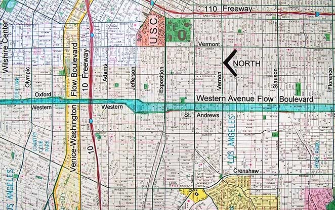
Western Avenue Flow Boulevard
Abstract
This Flow Boulevard is to initially improve transportation and development in the LA Basin portion of the corridor and then to connect and improve the same to the disenfranchised communities to the south of the I-10 Freeway eventually connecting to the I-105 freeway. The Western/Oxford FB brings the opportunity to reform and regenerate “inner city” communities with low cost multi-modal improved access. In 1975, the City Planning Department led by Calvin Hamilton designated in the Wilshire District Community Plan the incorporation of the portion of Western and Oxford between Melrose and Olympic as a one-way pair of arterials with the intension of it to become a Flow Boulevard. (A 2007 Plan and Statement follow)
WESTERN AVENUE FLOW BOULEVARD
OBJECTIVE: To become a renewed commercial and medium density residential corridor with improved vehicular travel capacity eliminating congestion. It should start in the Wilshire District and then progress southward.
BULLET POINTS
- What is depicted above is an improved future state where the elements of the FB are operating in Stage One development. This level of development might take form 8 to 18 years to develop.
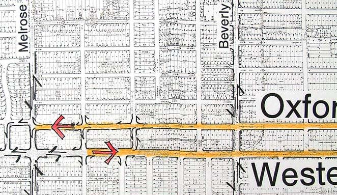
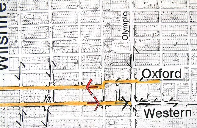
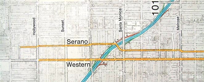
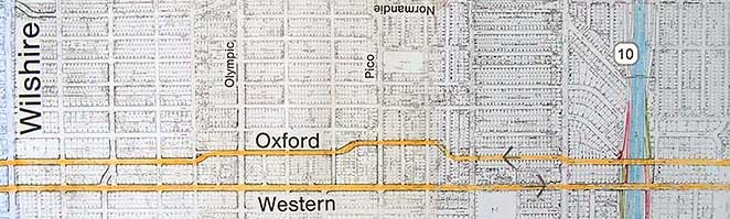
- The one way pair of streets, Western and Oxford Avenues have been designated and the signals synchronized for flow. A 100% vehicular capacity increase is achieved (the additional use of Oxford as a through street accounts for the higher than normal percentage increase). For the first 2 ½ mile segment (between Melrose and Olympic) there is no taking of private property and no loss of on street parking.
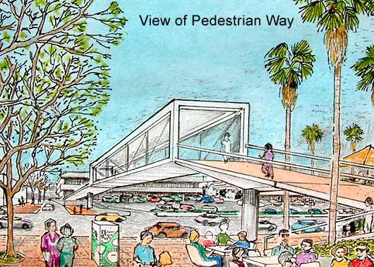
- The beginning of the raised pedestrian circulation system has begun to be constructed.
- New commercial businesses merge with existing enhanced commercial.
- New off street parking is developed to add to existing on street parking capacity.
- New residential structures add to the housing stock and the variety of housing types (seniors, empty nesters, new people to the area).
- True rapid bus transit with exclusive lane flow on Western Avenue is operational.
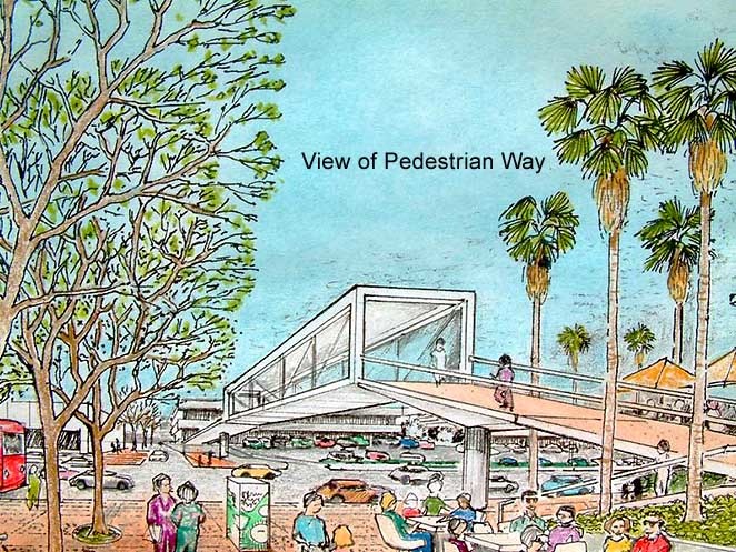
Pedestrian Circulation and Open Space The raised pedestrian circulation and open space system is a key element in the FB long range concept. The objective is to eventually have completely separate pedestrian circulation above and away from the vehicular travel at ground level. The first stage of the FB, depicted above, is a transitional point having some pedestrian street crossovers, but there are still ground level crosswalks at cross streets. Stage Three of FB development is when there is complete separation along and across the FB without going down to grade to cross at a street crosswalk. The intension is to make this pedestrian realm a safe and wonderful place to be. The pedestrian circulation links together the vest pocket parks, cafes, schools, amenities and service commercial so this becomes a walking neighborhood environment. This lineal “town center” is uniting adjacent communities as well.
New Residential Of interest here is that from 50 to 70% of population increase can be “organic”; more births than deaths. That can mean that when housing needs change, the people do not have to relocate out of an area if it has a sufficient range of housing types to meet the new requirements. Regarding circulation and open space in the residential areas, the idea is to basically use a multi-story building to free up space for that use. The roofs of parking structures, can be used as a platform for housing and for pedestrian circulation. The roofs of ground oriented dwellings around a park or ground circulation, can support raised pedestrian circulation and more housing (see the Architectural Considerations section for more images and concepts). Weaving pedestrian circulation in, around and along the FB corridor gives the opportunity for human scaled environments; the kind that would make unique and special, wonderful areas for people.
Flow on the Boulevard At present, in the Wilshire district portion on Western Avenue, there is approximately 36,000 daily vehicular trips. Due to lots of cross street signals and pedestrians, traffic is slowed and congestion is evident. Future growth in this configuration would lead to even more congestion becoming a not so good experience for pedestrian and driver. The Stage One depicted above with three lanes flowing on Western and Oxford would allow approximately 72,000 vehicles per day (1,200 vehicles/ hour/ lane X 10 Hours X 6 lanes = 72,000 vehicles). Bus rapid transit adds that much more person trip capacity. This would hold the travel demand in congestion free travel for many, many years.
Demonstration Corridor A western Avenue FB would be a perfect demonstration corridor in that the 2 and ½ miles between Melrose and Olympic has virtually no impact on private property. As can be seen in the plan below, the ends of the FB would revert back to two way traffic.
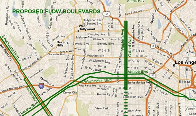
Granted, when traffic goes back to the two way street traffic, there would still be the same congestion level that there is today. But that is the reason for the demonstration; to compare and see how people like the improved movement provided by the FB. The intension would be to extend the success of the FB from the 101 freeway to the 10 freeway. The connection between freeways would provide an appropriate step in the hierarchy of roadways from large to small and small to large. The Western Avenue FB becomes capable of intermediate and local vehicular trips, getting people to and from work, school or where ever and home again. It brings more customers to the commercial parts of the corridor and it takes some local traffic off of the freeways that should not be there.
It should be noted that extending the FB from the 101 to the 10 (beyond the original Melrose to Olympic demonstration segment) would entail the taking of some private property and the necessity for bridge and some ramp connections at the freeways. Once this is accomplished you have a major urban transportation element and a very strong infrastructure for needed housing, improved land use and environment to build upon.
How Not to Do It ! Knowing that Los Angeles needs more housing, I know that housing should be put in places where the increased travel demand is met with boulevards with increased capacity to handle the demand. Developing FBs is not only for the purpose of solving for existing congestion, but for the purpose of providing the structure for community growth.
If you want an example of how not to do it, that would be West Hollywood along the Santa Monica Blvd. Medium density housing was developed in the 1960’s and 70’s and has resulted in “traffic crawl” on Santa Monica, Sunset and Beverly Boulevards as well as north south streets. The streets have not been improved in capacity, but have actually been reduced in the capacity to let vehicles move. The reduction has come about be the adding of more signals to accommodate pedestrians to cross streets in the enlivened commercial corridor of revitalized shopping. On Santa Monica Boulevard there are signals at nearly every other block (approx. each 660 feet) resulting in 6 to 10 mph vehicular travel. Another impact has been made with the “Grove” development in the Fairfax Neighborhood. Third street, Beverly and Fairfax are near immoveable during pear hour and on weekend nights.
Somebody is not allowing the necessary sensible transportation planning that will allow us to rebuild our communities without traffic congestion.
Extending South The image above shows the Western Avenue FB extending south from the 10 freeway. I would expect that two basic functions are taking place. Community land use renewal (housing, commercial, institutional, etc.) and a combined internal community vehicular circulation with improved commuter capability is being developed. The segments would extend as needed by first growing to Exposition, then Slauson, then Century, and possibly then to the 105 freeway.
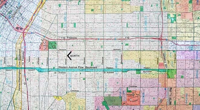
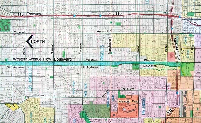
There are a number of street discontinuities, shifting alignments and land use developments that currently obstruct a clean, no impact FB construction extending south. Given time and the demands made by growth, all of these discontinuities can be overcome by creative growth development. A new shopping center now sits at Slauson blocking the Saint Andrews (the paired street to Western at this location) alignment from going south. In 40 years, or less, this shopping center will be old and in need of a lift and probable expansion. At that time, a creative adjustment and redesign can give the FB the needed extension south, the shopping center can receive an expansion and, by the way, better access to its stores (and offices and a hotel?).
Historic residential worthy of preservation, if in a desired FB alignment, can be moved (and given that long awaited improved foundation that was here to for unaffordable). Much of the old housing, in what is called historic districts, is marginal at best. They are useful today in providing housing and it is wonderful that people embrace and restore their neighborhoods. But in many cases the old house is a very big burden in terms of maintenance, probably a not so good example of “historic Building” and probably a floor plan and layout that conflicts with today’s living patterns and economics. Many of these buildings have been “subdivided” into two and four unit apartments. In this area of planning and city building, a full recognition of individual and community values should come into balance. The value of a road that benefits and serves many people can be easily seen as desirable. On the other hand, an old house that is instructive and a “living record” of time past, is also a value to many people. Yet, the historic building does not have to block the usefulness of the road improvement in order to be instructive. The historic instruction can occur in another location.
The Jesse Owens County Park at Century and Western Boulevards again blocks the proposed southerly extension of the FB (that would be Manhattan Place, the paired street with Western). There is a small golf course to the west of the park that could be annexed to make up for any loss of land due to extending Manhattan Place south as part of the Western Avenue FB. Alternatively, the westerly street of the FB may align through an “acquired” golf course and shift over to the Wilton Place going south to align with the new bridge that is constructed over to 105 freeway.
Los Angeles must develop urban design capability to solve for its growing pains. In each case, you are not only building an improved roadway, you are building a portion of a community, a neighborhood center. Spend the money and make everything better. The cost to benefit in any of the FBs I am proposing should easily work out to the positive side. Remember, it is not just the savings the road provides, it is new portions of a city, with an improved tax base, that is being built. And, FBs would also make the entire city work better, look better and be better to live in.