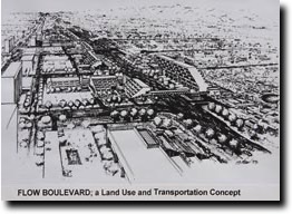
FLOW BOULEVARD
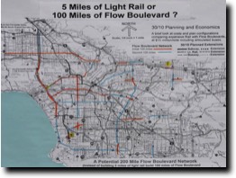
BRIEF OVERVIEW; 100 MILES OF FLOW BOULEVARD ARE NEEDED!
The Flow Boulevard concept has become a system comprised of two different boulevard types and the interchanges that connect them one to another, all of it having continuous flowing traffic on revised existing boulevard right of ways. The main advantage is to double vehicular capacity in existing corridors to create a network to solve both mobility and land use problems creating better communities throughout greater Los Angeles, and in other cities as well. Using existing boulevard right of ways has obvious affordability advantages as compared to other transportation modes and systems requiring new rights of way and structures.
The Flow Boulevard concept has become a system comprised of two different boulevard types and the interchanges that connect them one to another, all of it having continuous flowing traffic on revised existing boulevard right of ways. The main advantage is to double vehicular capacity in existing corridors to create a network to solve both mobility and land use problems creating better communities throughout greater Los Angeles, and in other cities as well. Using existing boulevard right of ways has obvious affordability advantages as compared to other transportation modes and systems requiring new rights of way and structures.
A New Roadway Architecture For LA
A new roadway architecture can organize traffic on selected boulevards to make “continuous flowing traffic on urban interrupted streets”. The interruptions are for cross traffic of vehicles and pedestrians as is needed in the urban context. The new roadway architecture works with the existing fleet of vehicles but can make even greater efficiencies by the use of the recent advances in vehicular technologies and the LA ATSAC (Automatic Signal Surveillance And Control) signal timing system. Combining these advances brings about increases in vehicular capacity which can eliminate traffic congestion and bottlenecks both big and small throughout the vehicular network. This will allow the LA Basin to “Fix its Traffic Problems” and protect its communities from traffic intrusion. The roadways can allow the suburban areas of greater Los Angeles to structure balanced growth in their communities, towns and cities.
A new roadway architecture can organize traffic on selected boulevards to make “continuous flowing traffic on urban interrupted streets”. The interruptions are for cross traffic of vehicles and pedestrians as is needed in the urban context. The new roadway architecture works with the existing fleet of vehicles but can make even greater efficiencies by the use of the recent advances in vehicular technologies and the LA ATSAC (Automatic Signal Surveillance And Control) signal timing system. Combining these advances brings about increases in vehicular capacity which can eliminate traffic congestion and bottlenecks both big and small throughout the vehicular network. This will allow the LA Basin to “Fix its Traffic Problems” and protect its communities from traffic intrusion. The roadways can allow the suburban areas of greater Los Angeles to structure balanced growth in their communities, towns and cities.
The Misguided Metro 1/2 Cent Sales Tax Increase
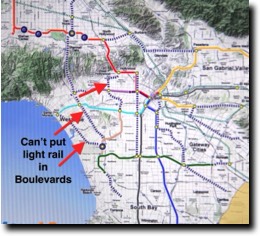
We need better planning. Don’t allow the vehicular network to be degraded with light rail in Boulevards, instead – Improve boulevards functionally and environmentally by “continuous flowing traffic on urban interrupted streets”.
We need better planning. Don’t allow the vehicular network to be degraded with light rail in Boulevards, instead – Improve boulevards functionally and environmentally by “continuous flowing traffic on urban interrupted streets”.
Flow Boulevard Planning in Los Angeles
The Flow Boulevard concept which is an at grade facility using existing street right of ways has grown from a low cost technique to eliminate transportation congestion and to improve land use relationships in a corridor is now also to be a community and multiple community strategy to reduce vehicular miles traveled and CO2 emissions and to absorb population that results in job creation, greater productivity and community growth with sustainability.
A breakthrough in traffic organizing by a new and improved Flow Boulevard (FB) conceptualization can now allow single street and couplet street Flow Boulevards to be connected from one corridor to another without the need of flowing traffic to stop at any signals. Because vehicular trips take less time by not having to stop at signals this also allows urban circulation at slower speeds which has greater compatibility with community residential and commercial environments.
Further good news is that the community and metropolitan scales of infrastructure improvement where Flow Boulevards can be applied have already been financed by the existing Measure R sales tax. That is by simply postponing a few expensive rail projects that now have little usefulness and transferring those funds to many miles of low cost Flow Boulevard projects that are much more beneficial and needed to the City and County of Los Angeles. An example proposal is contained in this study to use the Measure R $1 billion dollars allocated by Metro for some kind of connection from Westwood to the San Fernando Valley to instead be used to solve the entire Westside LA gridlock problem as well as the congestion in the Santa Monica Boulevard corridor from West LA to beyond Vermont Avenue in East Hollywood as well as to contain a very good BRT connection to the Valley.
Making better use of the Los Angeles legacy surface transportation system in selected corridors with balanced infrastructure and land use that is designed to preserve the quality of community life while serving the needs of commerce, is the objective. This broadly conceived infrastructure and community improvement helps bring economic recovery and establishes a path toward sustainability with reversals in problematical trends involving demographics, inequality, insufficient employment, debt issues and the lack of a sufficient vision of multi-modal transportation improvement that benefits all. It can be said that re-inventing greater LA for the 21st Century will require better infrastructure and communities to help bring that about.
The Vote NO on County Measure J Urban Design Study
Creative urban design and innovative transportation infrastructure are necessary to provide accommodation for two million more residents while eliminating congestion and providing for the development that supports the jobs, necessary community formation and the consolidation of LA County into an efficient, attractive and productive setting. A little more commuter rail by way of Measure J does not provide those objectives and is in itself inadequate in providing the transportation improvement needed in Los Angeles City and County.
A required transportation improvement must be an extensive low cost transportation and land use structure that is protective of urban and suburban existing development while necessarily being attractive to new businesses, housing and commercial development but importantly resulting in creating productivity, be supportive of a new larger economy and actually solving transportation problems with good urban design. Use of accelerated construction by Measure J of many unnecessary projects, borrowing from the future, using “cheap money” combined with the inadequate Metro plans can create a temporary Transportation Bubble, then a Crash and then our own lengthy LA County recession. Such a scheme as Measure J must be stopped so that better plans, objectives and public representation can be attained so our social, economic, environmental and transportation problems can be solved.
AIA Urban Design Committee Presentation
This short presentation was made for the purpose of generating a discussion on how transportation improvement can and should develop urban design in Los Angeles. A few overall points were made to frame what Flow Boulevards are about and their relevant characteristics that allow them to structure urban design. Three major points were made: 1/ vehicles provide over 95% of LA County mobility and must be improved upon in conjunction with our communities, 2/ Flow Boulevards are very affordable transportation improvements that can serve and protect at the community scale and they combine urban design as part of how they improve transportation, and 3/ knowledge of travel demand is essential in solving traffic congestion and developing appropriate urban design. (presentation and comments made 2012)
This short presentation was made for the purpose of generating a discussion on how transportation improvement can and should develop urban design in Los Angeles. A few overall points were made to frame what Flow Boulevards are about and their relevant characteristics that allow them to structure urban design. Three major points were made: 1/ vehicles provide over 95% of LA County mobility and must be improved upon in conjunction with our communities, 2/ Flow Boulevards are very affordable transportation improvements that can serve and protect at the community scale and they combine urban design as part of how they improve transportation, and 3/ knowledge of travel demand is essential in solving traffic congestion and developing appropriate urban design. (presentation and comments made 2012)
A 2012 Summary and SCAG EIR Comments
Besides commenting on the SCAG (Southern California Association of Governments) draft EIR/EIS the intent was to recommend adding the Flow Boulevard concept to the regional plans. The major point is to introduce land use and transportation improvement characteristics that are more of a natural outgrowth of the existing population distribution and its form of mobility. Then five examples with various scales of Flow Boulevard applications are referred to. That is followed by comments made in the framework of issues relating to the SCAG regional vision: Towards a Sustainable Future, The Economic and Population Setting, Challenges and Opportunities, and Sustainable Communities. A final Flow Boulevard example is made with The Plan to Eliminate Westside Congestion. (comments made 2012)
Besides commenting on the SCAG (Southern California Association of Governments) draft EIR/EIS the intent was to recommend adding the Flow Boulevard concept to the regional plans. The major point is to introduce land use and transportation improvement characteristics that are more of a natural outgrowth of the existing population distribution and its form of mobility. Then five examples with various scales of Flow Boulevard applications are referred to. That is followed by comments made in the framework of issues relating to the SCAG regional vision: Towards a Sustainable Future, The Economic and Population Setting, Challenges and Opportunities, and Sustainable Communities. A final Flow Boulevard example is made with The Plan to Eliminate Westside Congestion. (comments made 2012)
A Plan to Eliminate Westside Congestion
This is a subsequent improvement on the initial West LA/405 Corridor Traffic Improvement study made July, 2010 (see previous study). The key realization is that the traffic failure of the 405/I-10 interchange can be avoided as well by the addition of the Flow Boulevard as a frontage road in the 405 corridor. Now, along with other proposals by Metro (Expo Line and 405 HOV lane) a quick and relatively low cost elimination of all congestion on the Westside can be made. The specific 405/I-10 improvement is that the turning movements between the 405 and I-10 are increased in capacity so the interchange does not breakdown. This key factor lets the Valley traffic that now cuts through Brentwood and West LA to continue on the 405 as it should to the I-10 and on to Santa Monica. Likewise but to a lesser percentage, freeway traffic from the east and south of the interchange can go directly west on the I-10 to Santa Monica. Bus Rapid Transit on the Flow Boulevard also introduces robust transit quickly to the corridor and due to bus flexibility can connect directly to the multiple work centers to the east and west of the 405 corridor without transfers and delays. (plans and comments made 2011)
This is a subsequent improvement on the initial West LA/405 Corridor Traffic Improvement study made July, 2010 (see previous study). The key realization is that the traffic failure of the 405/I-10 interchange can be avoided as well by the addition of the Flow Boulevard as a frontage road in the 405 corridor. Now, along with other proposals by Metro (Expo Line and 405 HOV lane) a quick and relatively low cost elimination of all congestion on the Westside can be made. The specific 405/I-10 improvement is that the turning movements between the 405 and I-10 are increased in capacity so the interchange does not breakdown. This key factor lets the Valley traffic that now cuts through Brentwood and West LA to continue on the 405 as it should to the I-10 and on to Santa Monica. Likewise but to a lesser percentage, freeway traffic from the east and south of the interchange can go directly west on the I-10 to Santa Monica. Bus Rapid Transit on the Flow Boulevard also introduces robust transit quickly to the corridor and due to bus flexibility can connect directly to the multiple work centers to the east and west of the 405 corridor without transfers and delays. (plans and comments made 2011)
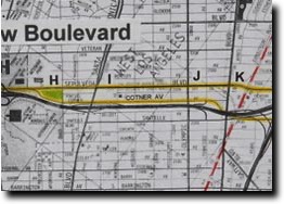
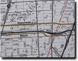
West LA/405 Corridor Traffic Improvement
This is the initial study using the addition of a Flow Boulevard as a frontage road to the 405 freeway on the Westside to eliminate congestion. In this proposal Sawtelle Boulevard between Culver and Pico Boulevards is the paired street with Sepulveda. North of Pico, Sepulveda is to be paired with Cotner Avenue up to Wilshire and then back into the Sepulveda alignment. In a subsequent study Beloit Avenue west of the 405 is used instead of Cotner. This initial study discusses a number of travel demand issues along the corridor between the City of Culver to north of Wilshire referring to the relationships between the 405 freeway and the operations of the Flow Boulevard as a frontage road. The major points have to do with relieving the deficiency in corridor capacity and the deficiency in turning movements to distribute and collect commuters between the 405 corridor and the Westside. The later Beloit alternative, namely A Plan to Eliminate Westside Congestion, approaches the subject of congestion more comprehensively by showing how the entire Westside instead of just the 405 corridor can be eliminated of congestion. (comments and plans made 2010)
This is the initial study using the addition of a Flow Boulevard as a frontage road to the 405 freeway on the Westside to eliminate congestion. In this proposal Sawtelle Boulevard between Culver and Pico Boulevards is the paired street with Sepulveda. North of Pico, Sepulveda is to be paired with Cotner Avenue up to Wilshire and then back into the Sepulveda alignment. In a subsequent study Beloit Avenue west of the 405 is used instead of Cotner. This initial study discusses a number of travel demand issues along the corridor between the City of Culver to north of Wilshire referring to the relationships between the 405 freeway and the operations of the Flow Boulevard as a frontage road. The major points have to do with relieving the deficiency in corridor capacity and the deficiency in turning movements to distribute and collect commuters between the 405 corridor and the Westside. The later Beloit alternative, namely A Plan to Eliminate Westside Congestion, approaches the subject of congestion more comprehensively by showing how the entire Westside instead of just the 405 corridor can be eliminated of congestion. (comments and plans made 2010)
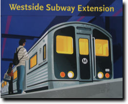
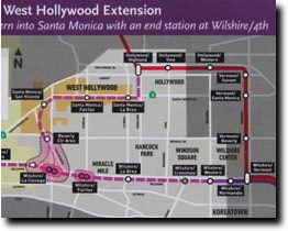
Subway Extension and Congestion Elimination
This October 2010 statement is a reminder that there does not have to be congestion in the LA Basin. A subway alone will not eliminate congestion extended to the Westside; it may very well increase congestion. The point is that there must be multi-modal improvement in such a major transportation corridor that improves both transit and vehicular modes. The issues also involve getting the corridor in the right place so it serves transportation needs well, for making good relationships with adjacent communities to avoid long term impacts and doing it at an affordable non-disruptive pace.
The Metro approved alignment extends westward from the purple line station at Western down Wilshire through a residential district. By this choice a number of poor transportation functions and bottlenecks are permanently put in place. It also sets in motion decades of adjacent community residential impacts that will change the character of the LA Basin. (comments made 2010)
Better More flexible Planning
This section is to respond to recent changes in economic conditions and seeks to expand considerations of what is necessary to better solve our planning problems. A “growth solution” is referred to as needed to adapt and also to be able to afford that adaptation. Bigger transportation concerns including longer time frames with open technology and system design affects planning choices. Objectives include countering sprawl with an economy of consolidation. Regional, sub-regional and city form imply “decentralized efficiency” as opposed to “centralized excess”. All these issues exist in a disconnected planning process in Los Angeles City and County. At the citizen grass roots level of participation through Neighborhood Councils; this also is disconnected. (comments made 2010)
This section is to respond to recent changes in economic conditions and seeks to expand considerations of what is necessary to better solve our planning problems. A “growth solution” is referred to as needed to adapt and also to be able to afford that adaptation. Bigger transportation concerns including longer time frames with open technology and system design affects planning choices. Objectives include countering sprawl with an economy of consolidation. Regional, sub-regional and city form imply “decentralized efficiency” as opposed to “centralized excess”. All these issues exist in a disconnected planning process in Los Angeles City and County. At the citizen grass roots level of participation through Neighborhood Councils; this also is disconnected. (comments made 2010)
LA City and County Overview
This study shows that the proposed rail system does not begin to address the amount of transportation improvement necessary for mobility needs nor would it be responsive to recent new planning criteria. What should be included in City and County plans is a low cost extensive network of improvements and plans to distribute population growth on that extensive network creating efficient home to work trips. Long term, in order to secure the future of the Southern California Dream, a totally integrated system primarily with electric vehicles may very well be the transportation goal. There is a great need for planning that allows for flexibility in order to be able to respond to new problems while taking care of the over 90% of trips in LA County which are vehicular. What we have is an economic situation that leaves us vulnerable because very expensive rail takes up a large part of the improvement budget with narrowly conceived goals that would serve but 3% of County trips. (comments made 2010)
This study shows that the proposed rail system does not begin to address the amount of transportation improvement necessary for mobility needs nor would it be responsive to recent new planning criteria. What should be included in City and County plans is a low cost extensive network of improvements and plans to distribute population growth on that extensive network creating efficient home to work trips. Long term, in order to secure the future of the Southern California Dream, a totally integrated system primarily with electric vehicles may very well be the transportation goal. There is a great need for planning that allows for flexibility in order to be able to respond to new problems while taking care of the over 90% of trips in LA County which are vehicular. What we have is an economic situation that leaves us vulnerable because very expensive rail takes up a large part of the improvement budget with narrowly conceived goals that would serve but 3% of County trips. (comments made 2010)
Westside Subway Extension Corridor
This is the initial set of comments on the subway extension made in May of 2009 that emphasized that the wrong corridor was being chosen. The major points that came from this study were that 1/ the corridor should be conceived as a multi-modal transportation corridor, 2/ that the right transportation relationship of the multi-modal corridor should be made to the LA Basin overall street plan and 3/ that the corridor should work well with the existing adjacent communities to protect them from impacts along with nurturing the development of future improved urban environments. The final proposed choice of subway extension alignment has functional flaws and is an incomplete design approach that has not achieved these any of these points well enough. (comments made 2009)
This is the initial set of comments on the subway extension made in May of 2009 that emphasized that the wrong corridor was being chosen. The major points that came from this study were that 1/ the corridor should be conceived as a multi-modal transportation corridor, 2/ that the right transportation relationship of the multi-modal corridor should be made to the LA Basin overall street plan and 3/ that the corridor should work well with the existing adjacent communities to protect them from impacts along with nurturing the development of future improved urban environments. The final proposed choice of subway extension alignment has functional flaws and is an incomplete design approach that has not achieved these any of these points well enough. (comments made 2009)
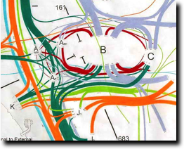
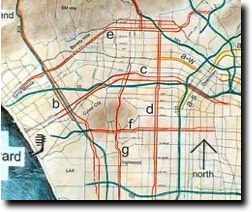
Comparisons of Various LA Basin Plans
What does planning for LA Basin transportation and land use needs involve? Different recent proposals are discussed. Plans discussed include a/ the NO Rail Plan (solving for travel demand), b/ The LA Basin Loop with Rail (showing multi-modal needs), c/ Metro’s Plans (they don’t develop multi-modal transportation or consider impacts to communities), d/ The 1973 Wilshire FB Plan (bottlenecks, impacts, wrong corridor), and e/ Pico-Olympic Plan (impacts, wrong corridor, traffic deficiencies). To summarize the acceptable plan should have adequate multi-modal transportation capability serving commuters, basin circulation and local use. Further it should give protection from traffic for existing established residential communities, the elimination of congestion, have provision for appropriate housing development and its connections to work centers, and all should be affordably obtained. (comments made 2008)
What becomes clear is the need to have a protective loop of vehicular circulation around the unique established communities of the LA Basin is needed.
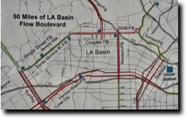
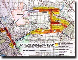
Santa Monica FB Corridor
Formally the alignment for the Beverly Hills Freeway, but it is still a corridor of immense travel demand through the northerly portion of the LA Basin. As one travels west, boulevards and streets are cut off by the Santa Monica Mountains making passage even more difficult. This corridor will fester with increased congestion as more commercial Westside development associated with an eventual subway and until there is a way to provide adequate through vehicular traffic and protection of residential communities from cut through traffic. This study shows a basic stage one Flow Boulevard alignment with some stage two anticipation of special treatments to provide adequate flow and capacity. This corridor must be secured soon so it can be worked on with urban design solutions over time to make necessary adaptive relationships between transportation and land uses. It is not an easy corridor but a very necessary one to make the Basin work correctly. (plans and comments 2008)
Formally the alignment for the Beverly Hills Freeway, but it is still a corridor of immense travel demand through the northerly portion of the LA Basin. As one travels west, boulevards and streets are cut off by the Santa Monica Mountains making passage even more difficult. This corridor will fester with increased congestion as more commercial Westside development associated with an eventual subway and until there is a way to provide adequate through vehicular traffic and protection of residential communities from cut through traffic. This study shows a basic stage one Flow Boulevard alignment with some stage two anticipation of special treatments to provide adequate flow and capacity. This corridor must be secured soon so it can be worked on with urban design solutions over time to make necessary adaptive relationships between transportation and land uses. It is not an easy corridor but a very necessary one to make the Basin work correctly. (plans and comments 2008)
Basin Loop Corridor Study
By leaving the LA Basin without improvement plans for movement of cars, trucks and buses long term circulation problems, bottlenecks, and community impacts will continue to mount. This study proposes a 30 mile loop of Flow Boulevards around the LA Basin that serves circulation needs while protecting existing communities from uncontrolled traffic. The loop is essentially comprised of four Flow Boulevards that each have different relationships to adjacent communities to solve for. They are the appropriate transportation facility to do the job because they relate to the community scale and along with architectural support make the needed response to solve transportation and land use relationships. (comments and plans 2008)
By leaving the LA Basin without improvement plans for movement of cars, trucks and buses long term circulation problems, bottlenecks, and community impacts will continue to mount. This study proposes a 30 mile loop of Flow Boulevards around the LA Basin that serves circulation needs while protecting existing communities from uncontrolled traffic. The loop is essentially comprised of four Flow Boulevards that each have different relationships to adjacent communities to solve for. They are the appropriate transportation facility to do the job because they relate to the community scale and along with architectural support make the needed response to solve transportation and land use relationships. (comments and plans 2008)
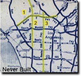
LA Basin Travel Demand
This study covers east-west travel demand using a manual assignment technique. A comparison of actual 2005 travel counts is made with a 2030 projection, and then an assignment of that 2030 demand is made to two east-west possible Flow Boulevards namely the Santa Monica FB and the Venice/Washington FB. The projection increased travel demand by 26% to which most all was assigned to the Flow Boulevard corridors. No rail transit was assumed to be used. This was to show how powerful the FB concept is in the ability to move people and goods. The City is going to build some rail but it will also need to build multi-modal transportation improvement, the protection of existing residential communities from increased traffic and to develop quality pedestrian environment in commercial corridors that also move vehicles. (Comments made in 2007 follow)
This study covers east-west travel demand using a manual assignment technique. A comparison of actual 2005 travel counts is made with a 2030 projection, and then an assignment of that 2030 demand is made to two east-west possible Flow Boulevards namely the Santa Monica FB and the Venice/Washington FB. The projection increased travel demand by 26% to which most all was assigned to the Flow Boulevard corridors. No rail transit was assumed to be used. This was to show how powerful the FB concept is in the ability to move people and goods. The City is going to build some rail but it will also need to build multi-modal transportation improvement, the protection of existing residential communities from increased traffic and to develop quality pedestrian environment in commercial corridors that also move vehicles. (Comments made in 2007 follow)
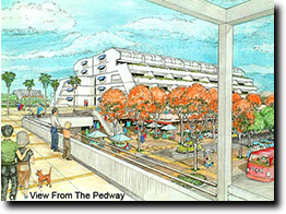
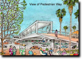
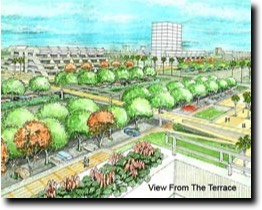
Stages of a FB to FB Intersection
Shown in model form the two proposed Flow Boulevards to study how an intersection would be developed are the Western Avenue FB intersecting with the Venice/Washington FB. This is essentially to show the first stage FB condition, which is grade level based, using traffic signals governing pedestrian and traffic operations. Then higher density becomes the impetus for the evolving of urban elements with three dimensional urban design organizations that bring the benefits of second stage development. This clearly shows how elevated pedestrian circulation, in this setting of increasing density, will not only allow smooth flow of vehicular circulation but also the development of a much desired pedestrian circulation and open space system establishing a rich urban experience. (plans and comments 2007)
Shown in model form the two proposed Flow Boulevards to study how an intersection would be developed are the Western Avenue FB intersecting with the Venice/Washington FB. This is essentially to show the first stage FB condition, which is grade level based, using traffic signals governing pedestrian and traffic operations. Then higher density becomes the impetus for the evolving of urban elements with three dimensional urban design organizations that bring the benefits of second stage development. This clearly shows how elevated pedestrian circulation, in this setting of increasing density, will not only allow smooth flow of vehicular circulation but also the development of a much desired pedestrian circulation and open space system establishing a rich urban experience. (plans and comments 2007)
A Review in 2007
First a summary using bullets is made describing Flow Boulevard characteristics and planning conditions calling for plans to design a better LA future. Following this are brief Abstracts made in 2007 of the then “to date” studies. Then, further commentary is made covering the solving of congestion and transportation needs by improving community environment in an evolutionary process to build a magnificent city. This is beyond just trying to improve commuter travel.
First a summary using bullets is made describing Flow Boulevard characteristics and planning conditions calling for plans to design a better LA future. Following this are brief Abstracts made in 2007 of the then “to date” studies. Then, further commentary is made covering the solving of congestion and transportation needs by improving community environment in an evolutionary process to build a magnificent city. This is beyond just trying to improve commuter travel.
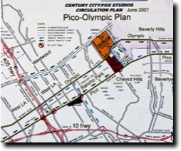
Open Letter to the Westside
The reason for the letter was basically to state that I had nothing to do with the choice if the Pico-Olympic one-way street project and that my corridor would be Venice and Washington for a FB. Pico-Olympic is the wrong corridor because it is widely separated and impacts residential communities so much. The letter became an opportune time to mention a number of issues that had been developing such as 1/ it would be good to rethink the Westside regional employment growth, 2/ become knowledgeable of the traffic context in the Basin generally, 3/ that a FB has many positive characteristics that help communities cope with the traffic and development conditions, 4/ BRT transit on a FB is truly rapid and 5/ a basin loop of FB corridors is a worthwhile objective among other ideas. (comments made 2007)
The reason for the letter was basically to state that I had nothing to do with the choice if the Pico-Olympic one-way street project and that my corridor would be Venice and Washington for a FB. Pico-Olympic is the wrong corridor because it is widely separated and impacts residential communities so much. The letter became an opportune time to mention a number of issues that had been developing such as 1/ it would be good to rethink the Westside regional employment growth, 2/ become knowledgeable of the traffic context in the Basin generally, 3/ that a FB has many positive characteristics that help communities cope with the traffic and development conditions, 4/ BRT transit on a FB is truly rapid and 5/ a basin loop of FB corridors is a worthwhile objective among other ideas. (comments made 2007)
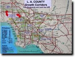
Los Angeles FB Network
This is a “first look” at what a Countywide FB Network might be like. There are population assumptions and distributions to allocate new growth. In regards to FB corridors it was assumed that 1.2 million people of population growth would be within these developing corridors over the next 25 years. And of course part of the exploration was to identify likely corridors themselves. By this initial look it is now realized that variations on the Flow Boulevard concept will need to be designed to accommodate various existing street patterns in suburban areas. Also since a FB evolves out of the existing street network it is likely the FB pattern will be disconnected at first by emanating from various towns and centers later to be connected in an overall County Network. (the plans and comments were made in 2006)
This is a “first look” at what a Countywide FB Network might be like. There are population assumptions and distributions to allocate new growth. In regards to FB corridors it was assumed that 1.2 million people of population growth would be within these developing corridors over the next 25 years. And of course part of the exploration was to identify likely corridors themselves. By this initial look it is now realized that variations on the Flow Boulevard concept will need to be designed to accommodate various existing street patterns in suburban areas. Also since a FB evolves out of the existing street network it is likely the FB pattern will be disconnected at first by emanating from various towns and centers later to be connected in an overall County Network. (the plans and comments were made in 2006)
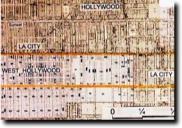
Western Avenue Flow Boulevard
This Flow Boulevard is to initially improve transportation and development in the LA Basin portion of the corridor and then to connect and improve the same to the disenfranchised communities to the south of the I-10 Freeway eventually connecting to the I-105 freeway. The Western/Oxford FB brings the opportunity to reform and regenerate “inner city” communities with low cost multi-modal improved access. In 1975, the City Planning Department led by Calvin Hamilton designated in the Wilshire District Community Plan the incorporation of the portion of Western and Oxford between Melrose and Olympic as a one-way pair of arterials with the intension of it to become a Flow Boulevard. (comments and plans made in 2007)
This Flow Boulevard is to initially improve transportation and development in the LA Basin portion of the corridor and then to connect and improve the same to the disenfranchised communities to the south of the I-10 Freeway eventually connecting to the I-105 freeway. The Western/Oxford FB brings the opportunity to reform and regenerate “inner city” communities with low cost multi-modal improved access. In 1975, the City Planning Department led by Calvin Hamilton designated in the Wilshire District Community Plan the incorporation of the portion of Western and Oxford between Melrose and Olympic as a one-way pair of arterials with the intension of it to become a Flow Boulevard. (comments and plans made in 2007)
Venice Washington FB and Sepulveda FB
Several new relationships are being identified between the Flow Boulevard and the adjacent community; new city block organization, block corporation development entities, relief to local and freeway facilities, and the need to provide a hierarchy of roads that protect the adjacent existing residential communities as well as future community organizations. Three Flow Boulevard corridors are given a preliminary look in plan view to show possible alignment and community relationships. The main corridors that are viewed with renewal options are the Venice/Washington FB and the Western/Oxford FB. The Sepulveda corridor has turned out to mainly be a “fit what’s broken” corridor with regards to transportation needs, as will be exhibited in more recent studies. This does allow improvements to land use elsewhere in the community however. (comments made in 2006)
Several new relationships are being identified between the Flow Boulevard and the adjacent community; new city block organization, block corporation development entities, relief to local and freeway facilities, and the need to provide a hierarchy of roads that protect the adjacent existing residential communities as well as future community organizations. Three Flow Boulevard corridors are given a preliminary look in plan view to show possible alignment and community relationships. The main corridors that are viewed with renewal options are the Venice/Washington FB and the Western/Oxford FB. The Sepulveda corridor has turned out to mainly be a “fit what’s broken” corridor with regards to transportation needs, as will be exhibited in more recent studies. This does allow improvements to land use elsewhere in the community however. (comments made in 2006)
Flow Boulevard and Community 2006
Beginning with the LA Basin context, it is important to know what the many transportation deficiencies are that exist. So a transportation model is used with land use planning techniques. New traffic solving relationships are identified with the use of the Flow Boulevard (FB) concept and community renewal opportunities are exhibited. The resolution of transportation needs and problems becomes the basis for investment and urban re-development in some areas and in others it will be shown as a way to protect communities. The discussion between rail and vehicular transportation continues through the text.
(comments made in 2006)
Comments on Rail Transit
Both subway and grade separated light rail are very expensive transportation options for extensive use in LA. They are usually used for suburban commuters to work centers. Therefore a more complete view of functions must be recognized and modes of transportation. It is a multi-modal transportation design that is needed to obtain a balance between transportation and land use functions in Los Angeles and its various communities. Where freeways and rail transit lines deal at the regional scale, what is of concern here is the sub-regional and community scales. This is essentially a domain where over 93% of the trips in LA County are vehicular and rail as proposed will comprise less than 3%. Vehicular trips work with these sub-regional and community scales not only due to economics but because they connect well to the land use patterns and architectural components that are Los Angeles in character. Therefore discussion of identifying what elements are needed to structure environmental and community needs is begun.
(comments made in 2005)
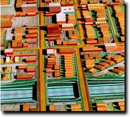
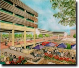
Architectural Considerations
Throughout the entire website the representation of land use has generally kept to architectural types of medium density and of typical prototypical forms so as not to complicate representation. The intent is to be pragmatic using architecture as one of the indispensable elements in the construction of the new kind of three dimensionally organized urban design for Los Angeles. Some initial architectural considerations due to these new relationships are mentioned here but will need much more study; sound, industrialized components, air rights and a practical expectation of character. Mega-structures (like the one pictured) are a long way off, whereas complexes of mixed use is expected to add up over time and is basic to improving the environment of the proposed corridors. It is to be expected as well that there will be a number of approaches to the process of change that involve an array of differing development participants, legal and financial entities and the roles of public and private participation, but that gets ahead of establishing what the basics are and the objectives for this new area of urban problem solving through urban design. (comments were made in 2005)
Throughout the entire website the representation of land use has generally kept to architectural types of medium density and of typical prototypical forms so as not to complicate representation. The intent is to be pragmatic using architecture as one of the indispensable elements in the construction of the new kind of three dimensionally organized urban design for Los Angeles. Some initial architectural considerations due to these new relationships are mentioned here but will need much more study; sound, industrialized components, air rights and a practical expectation of character. Mega-structures (like the one pictured) are a long way off, whereas complexes of mixed use is expected to add up over time and is basic to improving the environment of the proposed corridors. It is to be expected as well that there will be a number of approaches to the process of change that involve an array of differing development participants, legal and financial entities and the roles of public and private participation, but that gets ahead of establishing what the basics are and the objectives for this new area of urban problem solving through urban design. (comments were made in 2005)
FB Origination and How It Works
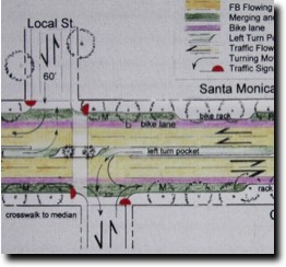
The Flow Boulevard (FB) concept originated in 1973 in recognition of the Los Angeles character of having long boulevards in low density settings that needed to move large volumes of traffic and provide for higher density development. This then becomes a staged concept where increased vehicular capacity in the existing street right of way and higher land use development can further advance by grade separating upward a pedestrian circulation and open space environment. This essentially becomes the three dimensional organization of urban elements into environments where vehicles have what they need to operate well and pedestrians have safe and aesthetic circulation areas for their benefit combined with the higher land use corridor. Many nuances and applications have emanated from the original concept and are portrayed on this website. See the text for “how it works” (vehicle operation in detail).
The Flow Boulevard (FB) concept originated in 1973 in recognition of the Los Angeles character of having long boulevards in low density settings that needed to move large volumes of traffic and provide for higher density development. This then becomes a staged concept where increased vehicular capacity in the existing street right of way and higher land use development can further advance by grade separating upward a pedestrian circulation and open space environment. This essentially becomes the three dimensional organization of urban elements into environments where vehicles have what they need to operate well and pedestrians have safe and aesthetic circulation areas for their benefit combined with the higher land use corridor. Many nuances and applications have emanated from the original concept and are portrayed on this website. See the text for “how it works” (vehicle operation in detail).