FLOW BOULEVARD
Comparisons of Various LA Basin Plans
Abstract
What does planning for LA Basin transportation and land use needs involve? Different recent proposals are discussed. Plans discussed include a/ the NO Rail Plan (solving for travel demand), b/ The LA Basin Loop with Rail (showing multi-modal needs), c/ Metro’s Plans (they don’t develop multi-modal transportation or consider impacts to communities), d/ The 1973 Wilshire FB Plan (bottlenecks, impacts, wrong corridor), and e/ Pico-Olympic Plan (impacts, wrong corridor, traffic deficiencies). To summarize, the acceptable plan should have adequate multi-modal transportation capability serving commuters, basin circulation and local use. Further it should give protection from traffic for existing established residential communities, the elimination of congestion, have provision for appropriate housing development and its connections to work centers, and all should be affordably obtained. What becomes clear is the need to have a protective loop of vehicular circulation around the unique established communities of the LA Basin. (Comments made in 2008 follow)
Transportation Corridor study
A Comparison of Various Plans
Contents
- The No Rail Plan (Initial FB 2007 Travel Demand and Assignment)
- The LA Basin FB Loop Plan with Rail (Expo and Subway Extension)
- The Metro Plan Deficiencies (In The LA Basin)
- The 1973, Wilshire Flow Boulevard Plan
- The Pico-Olympic Plan, FB Attempt
- Plan It, and Build It
Preface to Studies
The studies and partial studies briefly mentioned here will make a statement in regards to understanding what transportation planning for the LA Basin involves. For an even briefer description before the discussions take place, please note these differing plans.
Plans to be Studied The No Rail Plan shows that the travel demand for 2030 can be solved for without rail by the use of Flow Boulevards. On the other hand the LA Basin FB Loop Plan with Rail incorporates rail but shows that Flow Boulevards are still needed. The Metro Plan shows that it is a partial plan and that there are deficiencies in both land use and transportation planning. The 1973 Wilshire Flow Boulevard Plan is again a partial plan but points out some major land use and transportation problems that can occur if a Wilshire Subway were to be made. The Pico-Olympic Plan, is an attempt at a first stage Flow Boulevard, and shows that there would need to be a lot of mitigation to make it work, but in the end, it would still be a bad idea.
The Plan it, and Build it, which is a statement and not a plan; is rationale to say a comprehensive plan must be made! Transportation planning that recognizes land use provides the broad framework for planning an area such as the LA Basin. The planning that the LA Department of City Planning has been doing is put at a problem solving disadvantage because the major community structure, that of transportation, has been unrealistic by being incomplete. Because of inadequate transportation considerations the Community Plans being prepared reflect the past more than they reflect a desired and achievable future. Hopefully this kind of statement gets some critical response and review, because there is too much complacency in a time where change will happen in the LA Basin.
Characteristics of Note There should be greater coordination and comprehensive planning that incorporates transportation and land use in plans for the LA Basin. The following relationships should be kept in mind when considering Plans.
1/ LA must get to work solving its housing as well as its transportation needs. The LA Basin is an appropriate place to begin.
2/ A city wide network of higher density housing and higher capacity transportation corridors can solve these needs with the least amount of disruption.
3/ There are major future transportation deficiencies in existing plans that if not overcome can make an unbearable socio-economic situation where the loss of jobs, business and a productive population can occur.
4/ All communities must be up graded or safe guarded by their relationship to transportation corridors. Upgraded by direct improved development, and safe guarded by protecting adjacent residential areas from inappropriate land use and traffic impacts.
5/ Development should be made easy for development in high density transportation corridors and made difficult in residential areas where character and functional change is not desired or not given appropriate mitigation for traffic and growth impacts.
6/ Plans that incorporate the interests of business, developers of new housing, the population of existing communities and new transportation plans that overcome congestion, must work together.
7/ The plans must lead to an affordable citywide transportation plan to resolve congestion and provide the planning framework to build new higher density neighborhoods that connect to work centers.
The No Rail Plan Study
The 2007 Travel Demand transportation analysis that accompanies the Elements Study on this website (menu Elements and Travel Demand) is the No Rail Plan. It was made before I knew that Metro had so much money and were such big spenders. Thinking that money was scarce and transportation need so great, I wanted to show that the economical Flow Boulevard system could not only provide for establishing new neighborhoods and solve for traffic congestion but could accommodate a large increase in 2030 travel to and through the LA Basin. And the study shows that it would. The intension here then is to review some of the important points of the study and to compare them with the other corridor studies that follow.
This is one of the comprehensive corridor studies as opposed to partial studies also to be mentioned. It is comprehensive in that it deals with all expected year 2030 person trip (pt) travel demand through the LA Basin going east and west and shows an assignment of that demand to the networks and modes of travel for both the existing (2005) and the future (2030). The Travel Demand projections and analysis made in 2007 should be viewed as the base study to compare all of the following study plans.
When discussing plans for the Basin, the main area that needs the planning is west of Downtown. Downtown has benefited greatly in previous planning and has good access from north, south, east and west. Flow Boulevards and FB Spurs are recommended to further improve access as well as extensions and connections to evolving transit further west.
Not much has been stated about north-south travel demand west of Downtown. By studying the LARTS travel demand diagrams (see menu Travel Demand), it will become apparent that the Santa Monica Mountains create three separate points where commuting may enter the LA Basin. It then becomes an issue of how to distribute that commuting in an east-west spread. It is true that many north-south streets would need capacity increases if the Wilshire corridor is highly developed along with a subway West of Western Ave. But that would not be the case with a No Rail Plan or a LA Basin FB Loop with Rail Plan as is presented here. In these cases the Loop of FB’s provides the necessary east-west distribution and direct connection to work centers along the FB Loop. No need for revamped and widened north-south streets into the Basin central area to serve new regional employment west of Western going into Beverly Hills.
The south side of the Basin is somewhat similar having the Baldwin Hills as a restricting barrier of access. However the south side is also heavily influenced by freeways that the FB’s respond to and supplement. Here as well a FB (the VW/FB) becomes the major east-west facility for distributing commuting trips and a major facility for Basin circulation. But again, if Wilshire is highly developed then commuting and circulating traffic penetrates residential communities to connect with Wilshire. Expect major land use impacts and the need for expanded north-south street capacity.
To continue with explaining the 2007 base study, the assigned volumes of short, medium and long trips are on the correct kinds of transportation facilities and modes as well as being in the correct locations relative to each other and land uses. This is especially true in regards to positioning the Flow Boulevards correctly to the regional freeway network and in keeping traffic away from single family neighborhoods.
One major relationship that was recognized was that with the development of a Flow Boulevard system in the Basin, it would extend the “working life” of the freeways and their ability to perform for regional mobility. Another major relationship is one of positioning the Flow Boulevard between the freeway and the large established residential areas to be protected from disruption in the middle of the Basin. Another was in the case of the Santa Monica Boulevard corridor FB, that it is a matter of making the needed high capacity vehicular facility in that corridor so that it can absorb future travel demand and keep it out of essential residential areas. As will be discussed below in both the 1973 Wilshire FB Plan and the Pico-Olympic Plan, the positioning of regional employment as well as the FB is important to protect the established residential areas as well.
As mentioned above, the 2030 growth anticipated for travel demand through the Basin was an increase of about 27.6% above the 2005 actual travel demand. Also mentioned was that whether it took 25 or 40 years to experience that growth would not appear to matter given long range planning. The No Rail Plan study indicated that after increasing transit by over 100% (74,762 pt in 2005 to 154,076 pt in 2030) as well as increasing vehicular travel on the basic street grid, there was still a deficiency of 262,000 pt through the Basin east-west. Much of the increase was due to through traffic and the last few miles of long and medium distance commuter trips destined to the Basin. These are major volumes of medium and long trips that need major facilities for vehicles. It is important to mention that the increase in these trips would displace the local Basin residents that currently use the 10 freeway, therefore a need for improved internal Basin circulation is brought about. The increase of the medium and long trips destined to the Basin would also mean that the Boulevard and street grid would be unbearable and unworkable due to congestion without the two FB’s. In freeway design there is a facility that makes the transition between the Freeway and the adjacent land use called a “Frontage Road”. While somewhat similar, the VW/FB is performing many more benefits than that.
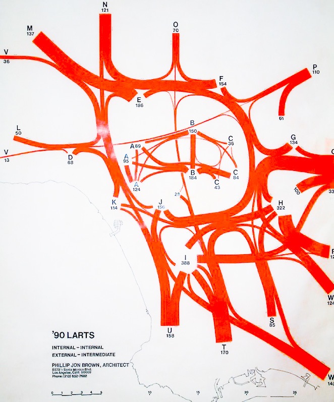
Hence there was the need for the addition of the two FB’s as the major transportation facility that would allow Basin residents circulation within the Basin and for vehicular commuting to the Basin from locations outside the Basin. In the east-west screenline count the amount of person trips to be assigned to the two Flow Boulevards was over 262,000 pt. To further understand the magnitude of travel to and through the Basin, it would be good to view the volume (by width of line) diagrams in the Travel Demand Study. To understand the magnitude of the commuter to the Basin, one should look at the External and Intermediate exchanging with Internal diagram (this one diagram is also shown below in the LA Basin FB Loop with Rail Plan and involves the majority of the Basin area as zones A, B and C). In 2005 commuting comprised about 1.795 million trips and would increase to about 2.3 million trips in 2030, an increase of about a half a million trips. Beyond this grouping of trips there are additional trips to be considered as seen on the other diagrams and/or the Basin composite diagram called Image X. Those images are without the 26.7% increase and basically reflect travel that was made in 2002, but the diagrams would be proportional to the 2030 travel demand. See the original 2007 Travel Demand study on this website to understand all the derivations, data sources, increases and notes regarding travel demand volumes and assignments.
Summary At the time of the 2007 No Rail Plan study, the transportation problems, facing the LA Basin was the main area of concentration. In subsequent thinking it has been recognized that a “protective” loop of FB’s had been formed that would conserve the centrally located residential communities, and areas outside the Loop for that matter. Now it is clear that the FB system is necessary to solve the congestion problem, provide new housing and neighborhoods connected to work centers and to conserve the unique LA feature of centrally located residential communities. This understanding has lead to the LA Basin Loop with Rail Plan that also includes rail for the benefit of regional commuters and because Metro has lots of money to spend on rail (too much in fact).
The importance of the Flow Boulevard concept itself is that by evolving just a few existing boulevards they can economically respond to the future travel demand requiring high capacities. And because of incorporating land use development as part of the transportation concept, existing commercial land use is maintained, given a bright new future mixing with housing in new neighborhoods and a whole new desirable urban fabric is born.
The LA Basin FB Loop with Rail Plan
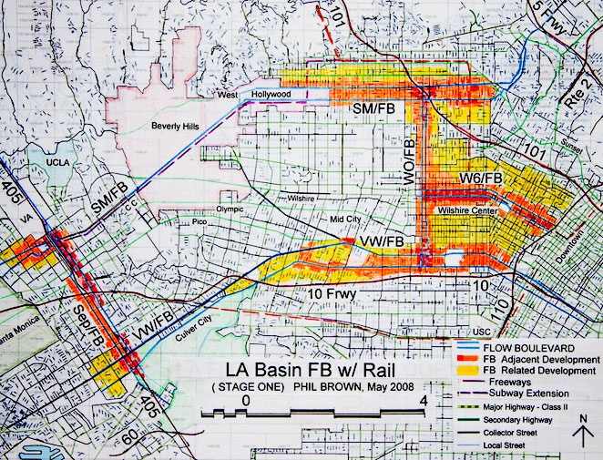
This Plan incorporates the Expo Line and the Red Line Subway Extension to the Sepulveda corridor. So there is not a Subway to the “Sea” plan, but there is a Subway to the “Freeway” plan incorporated. The Flow Boulevard Loop is needed because even with the presence of the rail projects there would be a deficiency of approximately 190,000 person trips (pt) in the 2030 travel demand east-west direction. The combined total of subway and Expo Line person trips at a screen line count at Fairfax would be about 70,000 pt. This is assuming both of these lines have reached the Sepulveda corridor and thereby drawing more trips out to that area. If the rail lines have not reached that westerly area the person trip count at Fairfax would be less.
Without the FB Loop there would really not be a way to circulate within the Basin due to excessive congestion. With the exclusion of Flow Boulevards, the deficiency results even with the entire projected 2030 pt increases for autos and bus to the street grid plus the Subway Extension and Expo rail lines. As a reference, the following increases briefly outline the additional volumes of new commuters (exclusive of through traffic but inclusive of internal to internal circulation). The Basin zones A, B &C (C is Downtown) commuters increase over 600,000 person trips (pt) from 2005 to 2030. Counting just zones A & B (A excludes Santa Monica) increases would be about 300,000 commuters 2005 to 2030. A more detailed explanation of the deficiency that develops and the potential resulting consequences are in the Metro Plan Deficiencies study below.
The combined plan of having a Flow Boulevard Loop and the two commuter rail facilities is probably the right way to go to make everybody happy. But it should be made clear that the Flow Boulevard in the Santa Monica corridor should take place before a subway is started. It should also be made clear that a subway in the direct SM/FB corridor would carry approximately 25% (approx. 37,000 pt at Fairfax) of the person trips in the combined facility where the FB itself would be carrying 75% of pt by autos and bus (approx. 110,000 pt). When considering adjacent street volumes like Sunset and Beverly (which would receive some reductions in the volumes experienced today) to be included in the corridor count the percentage of pt in the subway drops to 17% and for surface streets combined with the SM/FB would be 83% of person trips through the corridor.
The FB Loop would allow residents and the vehicular commuters a way to get around the Basin and the rail would simply be another way for some commuters to get to the Basin. Much of the commuter problem is also a product of having distributed regional employment centers. Employment is spread around the Basin. Downtown has most of the commuter trips but when the balance of the Basin regional employment is recognized, it may be 50% Downtown and 50% combining all the other sub-centers. The rail is brought into the FB Loop to serve the commuters to the distributed employment centers, but also to keep all that new traffic and regional employment growth out of the centrally established residential areas by putting a subway west of Western down Wilshire for example.
Downtown, the Loop and “FB Spurs” Where the FB Loop provides access around the LA Basin west of Downtown, it also gives improved access to Downtown with the extensions of the FB corridors and by “FB Spurs” extending out from Downtown. The VW/FB runs along the southern side of Downtown and would extend on into East LA. On the Loop plan is a Wilshire “FB Spur” running between Downtown and Wilshire Center on a Wilshire-Sixth Street pair ending into the WO/FB at Western Avenue. Sunset would be another connecting street from the SM/FB and the Route 2 improved link on Glendale Boulevard being provided by Metro (one instance where Metro and the City are coordinated).
In the LA Citywide FB Network (see website menu) there is a plan and discussion about “FB Spurs” coming out of Downtown. The Wilshire FB Spur is an elaborate example. There could be others towards South Pasadena, and East and South LA. These Spurs could be as simple as 1 or 2 flowing lanes with an exclusive BRT lane for each of the FB paired streets. The main objective is to get the benefit of transit having the advantages of synchronized signals to gain high average speeds and capacities from buses. And they are inexpensive too!
Solving Congestion and Protecting Residential Communities Making up for travel demand deficiencies is the first step in solving vehicular congestion. The 190,000 pt east-west deficiency noted above will be made up with two, Stage One Flow Boulevards; the Santa Monica Corridor Flow Boulevard (SM/FB, using a minimum of 3 flowing lanes in each direction) and the Venice-Washington Flow Boulevard (VWFB, using a minimum of 4 flowing lanes in each direction). The objective is to have an extra and exclusive Bus Rapid Transit lane in each direction. Where this objective is easily obtained in the VW/FB right of way (ROW), in some Hollywood portions of the Fountain Avenue side of the SM/FB and in West Hollywood, a shared BRT/flowing lane may be necessary in the early part of corridor development.
Staging, evolving and land use development is what a FB is about and how the increases in vehicular capacities are obtained. In the SM/FB corridor of Hollywood, where the Red Line is to be extended from in this plan, it is of particular necessity to begin building up the vehicular capacity and land use density prior to the development of the extended Red Line subway. Vehicular travel will increase as land use development anticipates the building of the subway and then follows up with further development attracting even more vehicular travel. The denser the existing development, the more difficult and creative the planning and development would have to be. Being anticipatory and to get the FB vehicular commuter capacity developed and the local ridership increased before the subway is put in place, is necessary. Regarding transit; beginning with local and express bus, it would then evolve to BRT with local bus and then subway with local bus and some BRT.
Commuting versus Circulating Corridor development and the increase in capacities have generally been presented above. But the relationship of the kind of increased traffic to the existing developed areas of the LA Basin, and how that future travel demand would affect it should now be focused upon. The issue can be presented as Commuting versus Circulating. There would be some 1,340,000 pt of commuting in 2030 between zones A and B (served by the Basin Loop) exchanging with the Valley, East and South LA and Beach Cities and beyond. But only about 7% of it would be by rail. Another 8% of it would be by various kinds of bus. Higher percentages of transit use into downtown would occur as opposed to the distributed work centers.
That means more than 92% of the commuters to the Basin west of Downtown (zones A and B in the LARTS diagrams) would be in an automobile, bus and truck vehicular mode. So the main consideration being vehicular which includes bus are where to put them so they serve the employment centers but do not over run and disrupt residential communities with traffic and incompatible land use. The incompatible land use in residential areas would be the regional commercial that would attract the long and medium distance commuters requiring a disruptive expanded street system. In most instances, regional commercial and low density residential do not work well together either. This is the major reason why a subway down Wilshire west of Western Avenue is not recommended (see 1973 Wilshire Plan below for further discussion).
The increase in commuters over 2005 is about 300,000 pt for a total of 1,340,000 pt coming from all directions exchanging with Basin zones A and B in 2030 (zones A and B exclude Downtown which is zone C). Look at the LARTS diagrams (menu Elements and Travel Demand) or the composite diagram Image X, to begin to realize that a few rail lines into the LA Basin west of Downtown does not even begin to solve for future travel demand. Look at the “Internal exchanging with Internal” LARTS diagram below and compare it with how huge the other movements are (note that the internal to Internal diagram is the small diagram with the A-B-C exchanges within the External exchanging with Intermediate diagram below). This should give you notice that the Basin trip generation is small compared to the commuter and through trips. Maintaining the ability for residents to circulate within the Basin in the future is a very serious problem. The street system is basically at capacity now. The only realistic and affordable way to gain additional needed capacity is with the Flow Boulevard system.
In the “Flow Boulevards Pay Their Own Way” portion of the opening LA Basin Flow Boulevard Loop discussion (not this “with Rail” segment), it was estimated there would likely be 120,000 dwelling units added along the Loop. Adding 120,000 DU’s along the FB Loop would not create the traffic problem in the Basin because they would be on the FB Loop facility that can accommodate that travel. The problem comes from the medium and long distance approximate 340,000 new commuter exchanges in the Basin excluding Downtown trips, or 600,000 new commuter trips including Downtown in 2030. The fact is that with the new dwelling units on the FB Loop there would be less medium and long distance commuter trips, and shorter FB trips to work centers by being on the Loop.
This brings us to “circulating”. Circulating is essentially what the residents of the LA Basin do in the LA Basin by going to work, school, shopping and all those other necessary trips. This travel demand is partly represented by the Internal to Internal exchanges between zones A-B-C diagramed above. There are also very short trips that do not leave zones (not represented here but is the chart in green on the Travel Demand analysis) and there are a few trips in the External and Intermediate exchanges with Internal (diagram below) were Basin residents go out of the Basin to work, etc. But those trips are very few as compared to the vehicular trips to and out of the Basin.
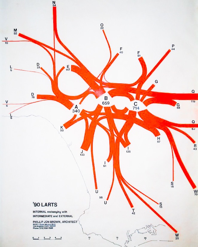
By comparing the commuting and through trips with the internal trips in the two diagrams above, it should be evident that maintaining congestion free circulation for residents must be a necessary objective. As it stands there is no help in this regard from Metro. By the development of the LA Basin FB Loop the necessary accommodation of commuting as well as the circulating of the Basin resident is performed. It will keep unnecessary traffic out of those established Basin residential areas, and it will add a very much needed area for growth of new neighborhoods connected to employment centers. The existing street grid, outside and inside the FB corridors, stays pretty much the way they are now except that the congestion would be removed. I believe that over time the transit use in the Basin will nearly double (14% of trips, with just 4% being on rail and 10% being on bus and BRT). But this goes along with the increased density of housing and new business in the FB corridors.
It is worth saying that both local and rapid express bus transit in the FB corridors should be fairly strong. Commercial shopping and services of all kinds should be available as well as employment and housing so that for many of the FB trips, autos would actually be inconvenient to use. This probable case would mainly be for residents in or adjacent to the corridor. The major trips to be accommodated however are the medium and long distance vehicular commuter trips because they are not only the greatest percentage of trips but they should not be using local streets. The following traffic projection and assignment to the SM/FB should point out some important relationships of the elements involved and it assumes the subway gets out to the Sepulveda corridor.
In 2002 there were approximately 161,000 pt traveling in the broad east-west Santa Monica Boulevard corridor (click menu Elements and Travel Demand, then see Image X in the Travel Demand portion). Projecting the 28 years to 2030 there would be 216,000 pt. That is an increase of 55,000 pt. Of that 55,000 expect 40,000 of those primarily vehicular commuter trips to go to the SM/FB itself. Then 15,000 pt of the increase would go to bus and the subway extension.
To tally up a total on the subway at the Fairfax screen line, it might be like this. There would be some shuffling of the existing and future bus trips in the Basin to the subway totaling 20,000 pt. There would be approximately 17,000 medium and long distance new commuters for a total of 37,000 pt on the subway. Also part of the shuffle is a 10,000 pt total on local bus and BRT. By adding the 40,000 new vehicular trips to the 2002 60,000 pt one finds a total of 100,000 pt on the SM/FB in vehicles. Divide the 100,000 pt by factor 1.2 to get 83,000 vehicles on the SM/FB (this is still a stage one FB capacity with 3 flowing lanes in each direction with bus mixed in). Percentages directly in the SM/FB give 25% of pt to subway and 75% to the SM/FB. Considering a wider corridor it would be 17% by subway and 83% vehicular. Like all of the corridors served by the FB Loop, the majority of the increases in commuter and through trips along with Basin growth in trips are being picked up by vehicles on Flow Boulevards. With out Flow Boulevards the city grinds down into “congestion push down” and fails (see the description below in Metro Plan Deficiencies).
So when issues of “congestion” come up and the heat is slowly being turned up (on us frogs in the Basin) while authorities are saying, “just get out of your cars”; you must start to recognize the lack of problem solving the LA Basin is being confronted with as Metro being the “default” planner. Residents must begin to fight harder and smarter with informed solutions to protect livability in the Basin. At present it would seem that Metro’s plans for LA have been simply planned by some suburbanites looking for a way to commute to work in LA but with no consideration of the impacts that would result on the LA Basin and its residents. This is probably too kind of a representation. I say this because it would seem that there is a strategy to generally make congestion to force people out of their cars. Well forcing some suburban commuters out of their cars may be reasonable but for the majority of people in the Basin this does not work. These same issues will eventually apply to other “sub-regions” other than the Basin. The Valley is probably the next large area. But there are pockets or smaller areas that can be affected as well, pay attention, Brentwood, West LA, etc.
Most residents in the hills and many flat land residential areas are a third of a mile or greater from a bus line. To do all the various errands and normal trips takes two and three times as long as by automobile. The message is we can not behave like frogs in the kettle while the heat of congestion is being turned up because what happens to the frogs is they are “done” before they jump out of the kettle to save their lives. Well we are not frogs, but the impacts of lost time, real estate value, spirit and opportunity for self, family and community through bad planning can make you feel like a very damaged frog.
This is not just a residential issue. The commercial corridors of the basin would be impacted as well. The typical strip commercial boulevard is impacted in that as traffic builds up and more signals are added to allow pedestrians to cross a boulevard, the corridor becomes a 6 mile per hour crawl or worse. This is why the typical grouping of housing and commercial on a boulevard like the existing Santa Monica Boulevard in West Hollywood ends up being a not so “smart growth” corridor. Commercial corridors must be designed so vehicles can move to, within and through it, to be attractive. That is why a Flow Boulevard can become a very “smart growth” corridor.
The Metro Plan Deficiencies in the LA Basin
Rail transit has very specialized transportation functions in Los Angeles. A radial pattern of railways concentrated on Downtown is obviously good for Downtown, but for distributed regional employment around the Basin more thought must be given to the layout.
It was lucky that the methane gas episode moved the MTA (now Metro) Red Line from the Wilshire corridor to go to the Valley instead of down Wilshire Boulevard. Wilshire alone simply does not generate a volume of transit riders to justify heavy rail subway and secondly there are the land use impacts and the vehicular deficiencies that will be discussed.
The Valley to Downtown subway configuration makes sense in a point A to point B transportation logic and in terms of modal split volumes of people served. The high volume of travel demand between the Valley and Downtown being constricted at the Cahuenga Pass, point A, has been given congestion relief with the increased capacity with rail to move people Downtown, point B. The 2005 modal split through the pass was roughly 300,000 pt by auto and 45,000 pt (screen line count) by the Red Line. The major point being made here is that in an urban corridor with strong travel demand, transit and vehicular modes can and should work together. Having few stops, no traffic, and a fast subway can make the medium length trip quickly; that is good. On the other hand the vehicular volume of trips is much bigger and needs to be taken care of as well or there is too much congestion. The combination of these characteristics and the high transit volume justifies the Valley to Downtown alignment.
In the Wilshire corridor a transit volume can easily be accommodated by bus. In 2005 the person trips by bus on Wilshire was about 18,000 pt and the east-west vehicular count at Fairfax Avenue was just 23,000 vehicles per day. If a subway were to be built in the Santa Monica Boulevard corridor probably half of the existing 18,000 transit trips would move over to the Santa Monica corridor. Local and Express buses can serve the different riders needs on Wilshire if there is no further regional employment developed. If higher density residential is developed in the Wilshire corridor west of Western Avenue into the year 2030, those additional trips can easily be accommodated with a BRT system on exclusive lanes.
And one must consider that the convenience of many east-west boulevards with bus transit for Basin bus riders, rather than promoting the idea of transfers to a Wilshire corridor to go east-west. If a subway were to extend down Wilshire west of Western along with attracted regional commercial growth, it would bring high volumes of vehicular traffic. That high volume of traffic would require road improvement for vehicular traffic along the Wilshire corridor and north-south, to and from the corridor. That scenario is dealt with in the 1973 Wilshire FB plan and the Pico-Olympic FB Attempt below. The subject is unacceptable land use impacts and radical changes to the street system in residential communities.
The Cahuenga Pass example of high person trip volume and the need to accommodate both vehicular (car, bus and truck) and transit trips through a point has application to the Sepulveda Pass condition as well. Metro should be thinking of how to deal with that growing travel demand rather than Wilshire. Again, knowing where the high volume travel demand is coming from and where it is going is necessary in developing a transportation network that truly solves transportation problems. The commuting demand has been touched upon above with combined geographical constraints through the Cahuenga and Sepulveda passes. A similar geographical constraint along the Santa Monica Mountains combined with the vehicular urban obstruction of Downtown occurs in the east-west direction making the Santa Monica corridor important and a better corridor to use for extending the subway west along with improved vehicular access.
Subway extension west, Santa Monica Boulevard or Wilshire corridor?
In the case of choosing the right corridor to extend a subway west, there should be recognition that major vehicular “commuting” will need to accompany that subway route. Both modes, vehicular (auto and bus) and subway rail transit are to serve the high person trip (pt) attractions of high density housing and employment centers. It would be important that the vehicular and subway route serves the large volumes of commuters to the Basin and has continuity from one end of the Basin to the other. The corridor that fits the criteria best is the Santa Monica Boulevard corridor (effectively Route 2) with connections to Downtown and east of that and on out to the 405. Both Wilshire and Santa Monica corridors have a subway connection to Downtown. The points to extend from to be compared are 1/ the Wilshire corridor starting at Western Avenue and going west, which is primarily into a low density residential area corridor, versus 2/ the Santa Monica Boulevard corridor which is a commercial and high density housing corridor extending west from Hollywood.
Going west on the Santa Monica alignment, Hollywood would be connected with West Hollywood, then Beverly Hills, Century City and out to the Sepulveda corridor which can include Westwood/UCLA. The Route 2 vehicular corridor of Santa Monica Boulevard has strong travel demand. A Flow Boulevard on Fountain and Santa Monica would concentrate the traffic to the SM/FB and increase vehicular capacity. With a subway, that makes an ideal combination of transit and vehicular capacity going through a high density high trip end corridor. The more direct subway route from the SF Valley to Hollywood then west without doubling back towards Downtown to go west also makes a great deal of sense.
Extending a subway west on Wilshire through a low trip attraction residential area can not be justified on the basis of passenger service. To put a subway down Wilshire and not allow development around it is the “unjustified expense” problem. Proposing and developing major regional (high rise) employment on Wilshire west of Western leads to horrendous community impacts. The corridor is not suitable for combining with vehicular improvement due to land use impacts, and if a Sixth Street and Wilshire Flow Boulevard were improved would become entangled in a vehicular bottleneck in Beverly Hills to the west (see Wilshire Flow Boulevard Plan 1973, below). This presents very big problems from both land use impacts and the concept that a combined improved vehicular and transit capacity would need so much change to go along with it. These transportation and land use problems are dealt will further below in the Pico-Olympic Plan study as well.
The Wilshire corridor between Western Avenue and the Beverly Hills business district is about four and a half miles long. However, in the Wilshire corridor, it is in the midst of a great sea of residential and fine single family neighborhoods. The difference of a subway going down the Santa Monica Boulevard versus the Wilshire Boulevard corridor may not seem to have substantial consequences until it is analyzed that it attracts so many problems associated with developing those 41/2 miles. The problems would persist for decades and in the end trying to solve the bottleneck in Beverly Hills going west is even a bigger problem. Making a Wilshire and a Santa Monica combined corridor, or separate set of corridors west of Beverly Hills really begins to incur transportation and land use impacts and expense. Following the Wilshire corridor another residential area is encountered with no real way to increase vehicular capacity without major impacts. Trying to double up the travel demands of both the Wilshire and the Santa Monica traffic flows, by putting them into a SM/FB would again over load the corridor and present major adjacent land use impacts.
On the other hand the Santa Monica corridor is the natural and continuous corridor from the San Gabriel Valley to the 405. The Santa Monica corridor has had major boulevard improvement between the 405 and Century City and should receive more improvement to serve the high density residential and commercial land uses already developed in the corridor on out to Hollywood and on into Glendale. Be sure to read the segment on the Santa Monica Flow Boulevard Corridor above to see how the alignment works and that there is innovative treatment of FB to land use relationships. For example it is proposed that a tunnel below a segment of the existing Santa Monica Boulevard be made for through traffic be built in the Beverly Hills area. This would leave the same conditions that exist today at grade in the year 2030 for connections in and out of the Beverly Hills Business District and related residential area.
What seems to be the problem regarding Wilshire is the myth that a “lineal urban core” should occur along Wilshire, still persists in the minds of some old time residents. The time for an urban employment center in that 4 ½ miles between Western and Beverly Hills has passed. We no longer live in the 60’s and the scale of Los Angeles has changed in how it works. The central and established residential Basin area should not be disrupted with what now would be radical change for the sake of a 50 year old developers’ myth. Be sure to refer back to the last few paragraphs of the Santa Monica Flow Boulevard Corridor study (above) entitled “A Change in the Scale of How Things Work”, for more on this topic.
The LA Basin needs a vehicular high capacity FB loop to solve congestion, to get commuters to employment centers and for residents to circulate on within the Basin. Along that loop are the established regional employment centers in the Basin. The established central residential area allows short commutes to the ring of work centers around it. The “Hills”, Hollywood and others fit into this schema as well. I can not think of any other American city that has such unique urban features as this. And that they can be preserved and made to function so well as with the transportation improvement that can be brought about with the Flow Boulevard concept.
The myth of a Wilshire subway and developing that 4½ miles of Wilshire with regional employment becomes such a costly and functional distraction with such land use impacts it must truly be considered as foolishness. The Park Mile is conceptually just fine the way it is and should continue with that premise. The Miracle Mile never became one and should not try. Instead of regional employment, community oriented commercial and higher density residential similar to that along Wilshire towards Westwood along with some institutional for cultural and educational purposed seems to be the more appropriate land uses. Regional employment in that 4½ mile area of Wilshire would compete with Hollywood and other centers and as stated previously would complicate vehicular circulation so it would not work. To politically strong arm a Wilshire subway would be a travesty that would set back Los Angeles from potential progress.
Congestion Push Down, a Capacity Deficiency Metro planners plan for rail and not for streets. But the overwhelming need is for developing vehicular (automobile and bus) capacity in the LA Basin. LA City has jurisdiction for what happens in the streets of LA but has no incentive to plan for them. These conditions can not be allowed to continue.
As stated in the above LA Basin FB Loop with Rail section, there would be over 600,000 additional or “new commuter” exchanges with the Basin (zones A, B & C) to be expected by 2030. The travel demand also to be expected is that around 93% of commuters would come in a vehicular mode (car, truck, and bus) to the A and B zones west of Downtown. It is not a matter of changing the habits of commuters by vehicle to being commuters by rail. There is not enough rail transit to reach the great number of dispersed commuters. Nor is such a system anywhere near being affordable. Rail supplements the vehicular network and hierarchy of roads in corridors with very high person trip travel demand. Regarding the need for additional capacity to overcome congestion in the Basin, plans with Flow Boulevards can accommodate that kind of travel demand. Metro’s plans without Flow Boulevards can not.
To try to compute the deficiency that a “rail only” improvement plan would develop is self defeating because people would never allow it to get that bad. To ballpark the deficiency even if the subway and Expo Line were in operation would put it at around 300,000 pt east-west at Fairfax. In the Loop with Rail section above it was stated the deficiency would be 190,000 pt east west, but that assumed that the deficiency would be picked up with FB’s so the transportation system would operate and not fail. Now what is being contemplated is what happens if you have the two rail lines but no Flow Boulevards. What happens with that much deficiency is the pervasive congestion diminishes the capacity of the whole system. All surface street and freeway facilities break down with the “congestion push down” effect described below.
In studying the basic failing system the “congestion push down” effect is identified. Going over various projections of volume in transportation facilities and modes, one begins to realize that even with a subway and the Expo Line the transportation system actually is less able to move traffic because the majority of the system, which is the vehicular system, has moved into failure status. With congestion throughout the hierarchy of roads there is actually less capacity in the system. The only way it works is by taking longer for traffic to slog through the gridlock. The availability and potential relief of rail transit, which basically serves some long distance commuters, is small because there is really very little rail network around due to not being affordable. One would see poor to upper-income/automobile-types in traffic jambs and lots of poor people in buses in the same traffic jams. The 2% of commuting rail “strap hangers” to the Basin, would also be very uncomfortable taking twice as long to go anywhere with connecting transit, waiting and walking.
Mentioning in this discussion the economic and class issues of rich and poor, suburbanite and urbanite is inevitable because transportation will polarize in congesting and deteriorating communities. Congestion can aggravate and put pressure on everyone. It is not life threatening it is livelihood threatening. The economic reference of rich and poor, while omitting middle income, is done to emphasize that the middle class in the Basin would probably be shrinking as it has in any American city where sprawl has been encouraged and “central city” areas have been allowed to congest. Typical cities would be Philadelphia and Chicago having their suburban “main lines” and New York City has its Long Island and Connecticut to commute to. In this polarizing condition the poor communities enlarge, the middle income areas shrink and the rich areas insulate themselves. Transportation can have social consequences.
The effect of “congestion push down” would appear in a number of places throughout the network of streets but the largest component of “push” would come from the lack of adequate capacity for high volume, long and medium length trip facilities; the freeways. The problem of the lack of freeway capacity, or as in the case of the Santa Monica Boulevard corridor (once to be the Beverly Hills Freeway corridor) produces similar results having a deficiency of capacity in a corridor with natural high travel demand.
With more regional and Basin development the increasing volume of long and medium “freeway type” trips occurs in the form of through traffic and commuter trips to the Basin. They begin to “push” local circulating Basin traffic off the freeway. Displaced Basin circulation traffic and increased commuter traffic to new Basin employment swell and exceed Basin boulevard capacity. That excess of traffic is then “pushed” onto Avenues and Local Collectors. The last “push down” occurs when traffic desperately seeks relief with “cut through traffic” in residential areas on a massive scale. Over an amount of time of living with the top to bottom congestion the tipping point is reached; sooner in some areas than others. The traffic tipping point is when deterioration begins and classic urban flight. The flight is of businesses and residents alike.
The prospect of some rich neighborhoods, but with mostly poor neighborhoods in the LA Basin does not seem possible that it could happen in Los Angeles. But I would insist that to deprive the “inner city”, in other words Basin residents, the opportunity to get to work and to jobs can over time have that effect. As it stands the plans are for more rail service; and they serve the suburbanite best. Metro is still working with plans for more sprawl and more commuting. Plans that would overcome congestion in the LA Basin and serve all economic levels of Basin residents do not exist. Solving congestion should be the higher priority.
Additional discussion is stated in the 1973 Wilshire Flow Boulevard Plan and the Pico-Olympic Plan sections below, regarding transportation and land use conflicts in the Basin. What is needed now is to recognize and embrace the idea that a new vision for the LA Basin can be shaped by a transportation system that works and recognizes the unique features of LA and what it can become. A transportation concept can begin to shape and structure the vision of what Los Angeles wants to be.
Metro Plans Leave the Basin with Deficiencies and No Vision As the above transportation comparisons show, regarding solving for future travel demand, a FB Loop can meet the needs of 2030 travel demand alone but the Metro rail only proposals leave deficiencies. The deficiencies are not only in terms of transportation but in understanding what the Basin is and how it works. Possibly it is the closed, dispassionate and limited view they have on transportation.
Metro’s plans are not only incomplete; they tend to withhold critical information that would have great consequences on whole communities. It is as though they are trying to put something over on the public. In the recent Westside Extension Transit Corridor Study presentations, there was no representation of what real transportation problem they were trying to solve on the Westside, certainly not congestion. They did not show whether their work engaged the right problem to be solved, whether the way they were going about it was an effective way and there was no measure of whether they would be solving it when they were finished. By my calculation they have failed in all areas. What they were able to do, however, was effectively take the public out of the process by promoting and passing Measure R. Now without considerable effort on the part of the public, correcting the flaws and destructive consequences of incomplete plans may be irreversible. Because of the misrepresentation of the real transportation problems in the LA Basin, the Citizens have been duped.
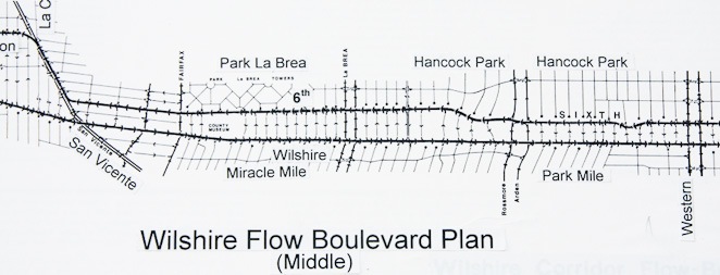
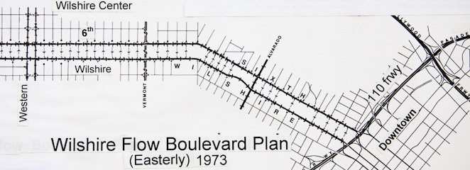
The 1973 Wilshire Flow Boulevard Plan
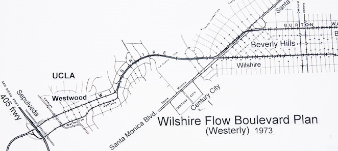
As a point of local history, the above plan was a proposal I made for the Wilshire corridor in 1973. The basic idea was that it would be better to make a “lineal urban core” rather than try to pull most all commercial land use Downtown. The Lineal Core would extend from Downtown out Wilshire to the 405 and employ a one way pair street configuration (FB) in order to accommodate the increased vehicular traffic. A subway was not of any consideration knowing that the diverting of trips from auto to subway would be a small percentage, maybe 5% of trips attracted to the corridor. Whereas a lineal core would definitely need high capacity vehicular access, the corridor could get along with bus transit rather than rail.
Times have changed and I have learned to appreciate to a greater extent the residential interests in this corridor. The way I see it now is that I would not recommend a commercial “Lineal Core” down Wilshire west of Western Avenue. But the problem is if a subway were to be built a Flow Boulevard would certainly have to be built along with it. Before the argument for “no subway down Wilshire” is elaborated upon, a bit more history. The 1973 Wilshire FB Plan became influential while working on the Citizens Plan for the Wilshire District that was then being prepared by a number of Homeowner Associations and the Wilshire Chamber of Commerce. I participated as a member of the Chamber.
The ultimate Citizen’s Plan that was presented to the LA City Planning Department rejected a Wilshire subway but incorporated a one way pair for Western and Oxford Avenues, which happens to be on the official Wilshire District Community Plan to this day. The winning attitude, put forward by the homeowners was, -do not “Manhattanize” Wilshire Boulevard-! But after the Citizen’s Plan was submitted to the Planning Department, the Wilshire commercial interests got together with Mayor Bradley and that started the subway down Wilshire. Once under construction, then the Lohman’s methane gas explosion helped divert the Red Line alignment to the Valley.
There is a lesson to be learned by this bit of history. Mayors tend to listen to developer interests more than they do to citizens. Short term and incomplete thinking may win out in that situation. This should put the residents of the Basin on notice; especially the residents of the central residential communities. In this case the Citizens should redirect developers to the plan that benefits the LA Basin best. I would think a Mayor would want to help in this situation.
The time to “Manhattanize” Wilshire has long since passed as has Gaylord Wilshire, the original promoter of Wilshire. Or maybe it has been Manhattanized up to Western Avenue. West of Western a mature fine residential community is firmly in place and the scale of Los Angeles has leaped beyond the scale of a single boulevard like Wilshire due to time and sprawling development. LA is now multi-centered with a grid of multi-county freeways and some regional rail transit as well. New realistic plans, rather than out of date sentiment, should be made to reflect the fact of how transportation travel demand really works in this new megalopolis and that the existing residential development in the LA Basin should not be critically disrupted with a small misplaced piece of subway and accompanying regional employment land use.
From a transportation standpoint the LA Basin needs just two Flow Boulevards running east-west. The Expo Line and the proposed subway extension can supplement the FB corridors. The Wilshire and Santa Monica Boulevard corridors converge into a bottleneck at Beverly Hills. Only one of these corridors should be developed as a high density residential corridor, with regional employment and major transportation; and that corridor would be the Santa Monica Boulevard corridor.
An LA Basin Loop can protect the unique residential feature of Los Angeles, provide for inevitable vehicular growth and extend the subway line west in the appropriate alignment of the Santa Monica Corridor. The east end of the Santa Monica corridor needs new development and the west end already has improvement for vehicles (see page two above). Flow Boulevards in the center of the Basin would be disruptive to the existing residential communities whether on Wilshire or Pico-Olympic and they do not work well with the travel demand pattern through the Basin. I would think a battle would emerge between residential areas as to where to put street widening for north-south streets and Flow Boulevards east-west. Eventually Flow Boulevards would probably end up in both the Pico-Olympic and Wilshire corridors as new vehicular traffic followed development brought about by a subway down Wilshire and more development in and around the 405 area. That would be exceedingly disruptive to the residential communities. Existing R-1 zone areas would be pressured to become R-3 areas which would add traffic to existing streets and change community character. The unique feature of residential communities surrounded by employment centers would be compromised and lost.
Remember that a regional employment center on a corridor west of Downtown would have about 12% arriving by transit (bus and rail), but only about 3% of the commuters would arrive by rail. Almost 95% would arrive by vehicle (auto and bus). That is approximately seven cars for every transit rider. The percentage of transit through the Basin (taken as a whole) east-west in 2005 was 7½% and was over 90% by automobile. So even with employment centers on transit corridors the real commuter to solve for arrives by vehicle.
Perspective of Wilshire Flow Boulevard
I would estimate in a developing Wilshire subway corridor that an additional three million square feet of commercial and maybe 20 to 30 thousand new dwelling units in the Wilshire corridor between Western and Beverly Hills would contribute to the vehicular demand of a total around 70,000 vehicles per day. That combination of central and attracted east-west commuter travel generally would end up needing a FB in the Wilshire corridor as seen in the plans above.
Regarding passenger volume on a subway (screen line not boardings) it depends how far the line runs and if it hooks up with other “supply”. The last stop might have 5,000 pt in a day, in a developed Wilshire corridor, if it was any kind of destination, (2,500 coming and 2,500 going per day). The screen line volume on the subway line increases as other stations are encountered away from the end of the line. The combined bus lines on Wilshire as of 2005 had about 9,000 pt east and 9,000 pt west per day at Fairfax, and the lines effectively extend from Downtown to the “sea”. As stated elsewhere however, a SM/FB with a subway would reduce existing and future demand down Wilshire greatly.
Spaced just one block apart from Western to San Vicente, Wilshire and Sixth Street provides an excellent one way pair configuration. Then the bottleneck of Beverly Hills occurs. As shown in plans the probable route to continue west would be Burton Way. Wide separation of a FB one way pair, in this instance, is not good because there is a mix of commercial and residential creating an on going conflict. Between Beverly Hills and the 405, the Wilshire corridor is not able to develop a one way pair without great change. The logical westerly route from Beverly Hills would be the Santa Monica Boulevard corridor. With a developing Wilshire corridor and the “Route 2” travel demand then coming together at Beverly Hills a major FB development would be required for those combined demand volumes. A demand of 130,000 vehicles per day would not be surprising to expect in the Santa Monica FB from Century City to the 405 under that condition. It is just asking for trouble of inducing such a traffic bottleneck and having to try to undo it. Just two Flow Boulevards are needed east-west through the Basin, the Santa Monica/FB and the Venice-Washington/FB for year 2030 travel demand, and they run the entire length of the LA Basin with great continuity.
The Pico-Olympic Plan, FB Attempt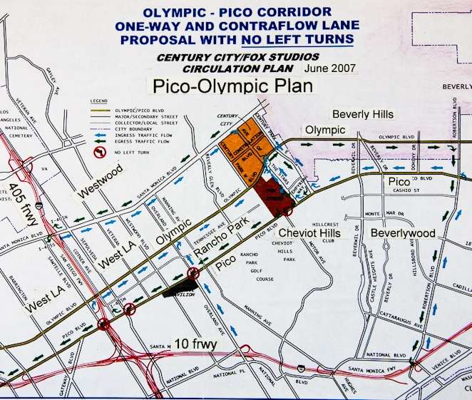
Generally Pico and Olympic Boulevards should be used for the benefit of the local Basin residents and therefore should not become a Flow Boulevard (FB). Pico-Olympic should not become a first stage FB in a one way street couplet operation that would attract regional commuters and excessive development of land use density. The City of LA with political prompting, brought about the Pico-Olympic study without really understanding what Flow Boulevards are to be used for and how they should be placed in the hierarchy of roads within a setting such as the LA Basin. My recommendation is against a Pico-Olympic FB and comes from the standpoint that it would introduce radical change and disruption to the adjacent residential communities. The appropriate and “first choice” corridor to develop would be the Venice-Washington corridor as represented in the LA Basin FB Loop Plan. The reason the Pico-Olympic corridor is included in the study is to express the dimension of traffic and land use change that would be brought about and that Pico–Olympic is potentially a “second choice” that could come about under current City planning.
What would a Revised Pico-Olympic Plan be like? The City plan is full of community impacts and has little transportation benefit. So the first thing to do is reverse those characteristics. Elimination of the bus contra-flow operation should be made because it stops the flow and synchronization of signals on each boulevard so that there is only a 6% increase in capacity. Without contra-flow bus there can basically be a 50% capacity increase on Pico and Olympic while keeping exclusive lane BRT transit. Regarding bus operation to connect riders with a “return” trip, a shuttle would be made available between Pico and Olympic.
In 2005 the average daily volume of vehicular trips on Pico was about 32,000 and on Olympic was about 45,000 giving a total of about 77,000 vehicles plus bus pt. In a first stage FB having synchronized signals, flow could have about 115,000 vehicles per day plus bus pt for the pair. There would need to be improved north-south street capacities as well to serve the increased volumes. Some of these would need to be in what are now single family neighborhoods. For example at the corner of Pico and Overland Avenue going north may best be improved with a one way pair of Pelham and Overland thereby extending the two lanes in each direction that Overland has south of Pico. And this may continue up to Santa Monica Blvd. In time higher zoning and a change to greater density to respond to a new relationship to the streets may be desirable to remove impacts to the single family home area. Other changes in streets and land use densities would be needed to be sure. More FB to neighborhood conditions of change would be developed in a study and should be identified for citizen response before going forward with plans.
The deficiency in east-west person trip travel demand, even with a subway and an Expo Line, has been stated to be about 190,000 pt. If the first stage Pico-Olympic FB would have a 50% increase in vehicles (38,000 X 1.15 person/veh. = 43,000 pt) along with an increase of 7,000 pt for bus, that is a total of 50,000 more person trips. That still leaves a basic deficiency of 140,000 pt east-west for the Basin. But since the Pico-Olympic increased capacity does not work well with the major travel demand corridors in the Basin, more than the 140,000 pt capacity would have to be added. Both the SM/FB and the VW/FB would probably be needed even though a Pico-Olympic FB were in effect.
The LA Basin FB Loop concept of protecting the existing residential areas, especially within the loop, can be violated by not only the emergence of a Pico-Olympic One Way Couplet (FB) but with the development of the Wilshire subway as well. Since the Wilshire corridor does not have good east-west vehicular continuity, the Pico-Olympic corridor could attract that function to serve the Wilshire corridor and to avoid the Beverly Hills bottleneck. The prospect of serving the vehicular needs of a growing Wilshire subway corridor; Wilshire Center, to Park Mile, to Miracle Mile, to Beverly Hills, Century City, Westwood and the 405 corridor is something citizens have to think about. This is because Pico-Olympic can not serve that big of a need. And it would certainly have big impacts on land use.
The Wilshire corridor and the Santa Monica Boulevard corridor converge at Beverly Hills. Beverly Hills would have a very expensive bottleneck and it would not be a happy situation. At present, traffic tends to favor the northerly east-west boulevards. In 2005 Sunset had 50,000 veh, Santa Monica 39,000 veh, Beverly 41,000 and Wilshire 23,000 at the Fairfax screen line. The northerly, route 2 corridor carries both long and medium length trips and you can not expect that pattern to change. It is logical and I think imperative that the Santa Monica corridor be maintained as the major corridor for vehicular continuity and along with it the subway alignment.
With a Santa Monica Flow Boulevard and future subway, that relieves the Pico-Olympic corridor and the Wilshire corridor west of Western from traffic and land use growth pressures. Flow Boulevards need not be built there. As the No Rail Plan study showed, only two Flow Boulevards (the SMFB and VWFB) are utilized east-west along with an increase in bus transit to carry the increase in person trips for 2030.
Plan It, and Build It
The above corridor studies are meant to exhibit that flaws in partial and narrowly conceived plans will not get it right. Either because they are lacking in breadth of scope or in the consideration of details, there are transportation deficiencies in the Metro plans and there will be unintended consequences regarding land use impacts. With Metro being overly focused on commuting, it would leave unacceptable congestion in the LA Basin. By Metro not recognizing that 1/ there will need to be increased vehicular capacity to solve for congestion, 2/ that development of an affordable citywide Bus Rapid Transit system is needed to get LA to work and 3/ that housing in new neighborhoods close to work centers are an urban necessity; the crucial problems in the LA Basin are not going to be solved.
On the other hand the LA Basin FB Loop Plan with Rail would solve the problem of vehicular congestion, provides the Basin portion of the citywide exclusive lane BRT system while defending established residential communities and also would promote new housing and neighborhoods in transportation corridors connected to employment centers. Most of the FB’s would go through areas that need or can take advantage of revitalization and constructive growth. In the up scale established residential neighborhood, the traffic needs to be contained and the neighborhoods preserved. The Flow Boulevard approach can do all of this. And finally for the suburbanites that commute, the rail lines are positioned to accept their commute without engendering the ire of Basin residents.
The LA Basin can enter a new growth era where it can potentially solve problems and make itself better. Whether it becomes a meandering crush of traffic and deteriorating neighborhoods by not solving traffic congestion or a time of creativity with great benefit for all depends greatly on planning. A vision must be understood, documented, approved and then the developers and citizens set forth to build it. An appointment should be made to the vacant City DOT Bureau of Transportation Planning. Los Angeles is in a traffic quagmire and there is no realistic representation of the LA interests, for both business and residential, on transportation issues and the needs of LA citizens. The planned elements of transportation planning, if realistic, can give a framework so the Department of City Planning can confidently work within it. If the framework of transportation keeps changing or breaks down by being inadequate, it has not answered the needs for mobility and the plans for land use will likely have to change as well. How can serious development and desired preservation occur, without good comprehensive planning of transportation and land use?
In the future there is much more work and innovation to be made in terms of planning. Traditional planning has mainly been a two dimensional kind of design activity. There will be the necessity to deal with three dimensional design where different owners and periods of construction may occur vertically. The elements of transportation and land use will become woven together in order to perform better for our needs. This is new and it would probably effect many important building professions to some degree. The City may need further code provisions, legal processes, economic strategies and ways to bring public and private construction together. But that is not needed now to get started.
At present there is an economic crunch and there are some ideas which favor jump starting the economy with shovel ready construction projects. Certainly the LA Basin FB Loop ROW can be given an initial clean up with road repair and rolling back some curbing where parkways are ridiculously wide. This would simply be a down payment on the idea that Flow Boulevards can make the city green by saving resources, arresting sprawl, increasing transit ridership, and reducing the length on home to work trips by many miles. The money should go towards a system that builds a citywide network (such as a 135 mile LA Citywide FB Network, see menu) so that all communities will benefit. The most wasteful use of transportation money at this time would be in making a subway extension west of Western Avenue on Wilshire Boulevard. Those developers looking to build multi-million dollar condominiums around subway stations will (should) have to wait.
As recovery of the economy comes about there might be a demonstration corridor developed as well, complete with synchronized traffic lights. Later when the benefit to Los Angels is clear and commitment to the FB concept has been made, many new jobs and businesses can emerge in the new activity of urban construction, financing, marketing, insuring, sales, so on and so on. Precast concrete companies should find many new applications and products. Not only will there be roads, bridges, and all kinds of buildings but the utility infrastructure should be updated as well.
What would be happening in a macro economic sense regarding growth in the City is that growth “overhead” would be reduced as opposed to expensive continued sprawl and more extended transportation expenditure. The efficiencies of city form consolidation with techniques that the Flow Boulevard concept would introduce can make the productivity of Los Angeles go that much further. Less would be spent on transportation and therefore able to be used elsewhere. And remember Flow Boulevards pay their own way and then some.
My guess is that there will be some unforeseen LA County expenses that will occur in the future and that part of the $190 Billion flowing to Metro over the next twenty five years will have to be used to pay for it. There are many possibilities for deficits to occur as we are now experiencing with so much prominence. Metro may become a Transportation Planning Organization and a back-up social agency of some kind if recent history is any indication. The prospect of many seniors living in poverty would address that kind of a reality.
The first stage of a Flow Boulevard is not an expensive proposition if the Right of Way has continuity. That is the case for 99% of the FB Loop. Signage, lane striping, some curb modification and the synchronization of traffic signals can give the desired increased vehicular capacity that will help solve traffic congestion. The 1% where substantial construction is involved is but a minor obstacle to overcome in order to gain such an important benefit for Los Angeles. And Caltrans will simply have to pick up the bill of making FB to freeway connections when it is recognized that FB’s essentially save the freeways in their ability to operate well, into the future.
In the case where freeways are encountered, those obstacles can be side stepped for some time. The Western-Oxford FB need not connect to the 101 freeway and the Santa Monica FB for some time. Further south on the WO/FB, it need not extend south beyond Washington Boulevard for some time. The tunnel under the 405 to connect Cotner to Sawtelle is probably the first Caltrans accommodation to be made, but that could maybe be put off for some time; the same with SM/FB to the 405 work. For the most part the substantial construction points would not interfere with many miles of congestion relieving FB operation, while those points of specific obstacle were being reconstructed. This is all the more of a reason to start now.
Just for the sake of being open, the next segment to be studied, and possibly put on the web, will focus on solving for ROW discontinuities and various prototypical street-building and overpass structures. In the “Elements” segment on this website, there is a treatment of the Oxford portion of the Western-Oxford FB, where an alignment discontinuity gave necessity to purchase 16 residential lots to connect Oxford to Oxford. This instance simply involved planning, acquisition, road building and a bridge over a park. The next segment to be studied will try to be more specific in terms of what I will call an architectural scale. Here a list of the discontinuities will be developed for the FB Loop with conceptualization of how to remedy the discontinuity with an architectural and urban design approach. Secondly a preliminary look will be taken at prototypical solutions for the street-building and overpass structures category.
The LA Basin Flow Boulevard Loop; time has come to, plan it and build it.