FLOW BOULEVARD
Basin Loop Corridor Study
Abstract
By leaving the LA Basin without improvement plans for movement of cars, trucks and buses long term circulation problems, bottlenecks, and community impacts will continue to mount. This study proposes a 30 mile loop of Flow Boulevards around the LA Basin that serves circulation needs while protecting existing communities from uncontrolled traffic. The loop is essentially comprised of four Flow Boulevards that each have different relationships to adjacent communities to solve for. They are the appropriate transportation facility to do the job because they relate to the community scale and along with architectural support make the needed response to solve transportation and land use relationships. (Comments and plans made in 2008 follow)

Preface
In that the plans associated with the passage of Measure R do not solve for traffic congestion in the LA Basin or consider various impacts to land use, the following “preliminary” LA Basin FB Loop Plan and Transportation Corridor Study is set forth. Regarding the pre-vote Statements urging a No Vote on Measure R, they remain as a record at the end of this Plan and Study presentation.
Even though it is better to start with a good plan than a flawed and incomplete plan, at least with the passage of Measure R there will be more transportation money. Adding the $30 to $40 more billions from R to the $152 billion Metro already had coming in (Metro 2008 LRTP draft page 23) makes about $190 billion to spend over the next 25 years. The question now is how to best spend it.
One item on the Measure R list was the subway extension west. To quote a recent LA Times article written by Steve Hymon regarding the ”implementation” of Measure R Steve wrote, “Roger Snoble (outgoing Metro Chief) told reporters that the so called Subway to the Sea could take decades to be built, causing Los Angeles mayor Antonio Villaraigosa – its primary proponent- , to quickly step in and insist that it would not take that long”.
What I question is not only when it goes but where it goes and how it goes. Having attended many of the Metro presentations leading up to the vote, the Metro planners said that their studies would include an impact study and that citizen input would guide the choice of alignment not a list of projects on a ballot. Both a Wilshire and a Santa Monica Boulevard corridor subway were outlined in presentations. But the idea of two subways was certainly done to create excitement and votes in some quarters. It is hard enough to justify one subway let alone a second and redundant subway 6 miles long ($3 billion plus impacts). In addition, if changes needed to be made, such as things not on a list for example, or changes like alignments, there was a process through the Metro Board to do it. And the overall plan would have to be approved by an agency of the US Department of Transportation, if there were matching funds for example.
As a concerned citizen it would seem that the process goes behind closed doors. And with the current era of rail transit fundamentalism, balanced “oversight” can not be expected. So I question the overall process, as well as when it goes and also where it goes. To date there has not been enough inquire, exploration of planning alternatives, plan elements shown as to how they would add up overall and there has not been a process that truly brings about an informed public response. It is in this light and towards that contribution that the following plans and corridor study for the LA Basin is made. The planners, the politicians, and the public, need to ask more questions and make more plans in order to get it right. I do not think the residents of the LA Basin have been rightfully represented.
First of all I more than suggest that part of that money be spent on solving traffic congestion and in helping to establish a visionary plan for a better environment in Los Angeles. As it stands the Metro plan favors the suburbanite commuter over the LA Basin resident and looks to impact communities and to restrict the movement of residents within the Basin. That policy can lead to a diminished standard of living, accompanied with social and economic problems city wide. We need better plans than what Metro has proposed so far.
Overall, Metro has applied a theoretical planning viewpoint to the region involving too much rail for commuters that has too big of a network and is too expensive; the concept behind the plans has been stretched too far. It is starving off sub regions from developing as they should. The mantra of getting people out of their cars is taken to a destructive extreme when they can not take advantage of transportation efficiencies such as the Flow Boulevard concept. Plainly stated, Metro’s plans are overly involved with suburban sprawl and commuting. They do not concern themselves with sub-regions, their congestion and local impacts on community land use.
The fact is, a myth has been created that a subway will relieve traffic rather than create it. A subway will attract further development, and generally with it seven times the number of new vehicles for each new transit rider. Depending where that new subway line would be put, that would start to describe how many communities would be impacted by congestion. And depending on what kind of immediate vehicular facilities were present along with the subway line, how big the immediate vehicular congestion would be. The Flow Boulevard concept develops greater vehicular capacity for autos and rapid transit buses within existing boulevard rights of ways to solve congestion. As can be seen in the LA Basin FB Loop with Rail Plan a Flow Boulevard and a subway extension would be need to be developed together, as is recommended in the Santa Monica Boulevard corridor.
Metro does not seem to recognize the value of urbanity, living close to work centers, the uniqueness of urban features in the LA Basin or that they can make terrible land use impacts locally. Another fact, they are not paid to do so. The City of LA has the responsibility of what happens in city streets, and the City does not work with Metro to see that congestion will not happen.
The Flow Boulevard system can provide areas of consolidation and growth without traffic congestion. It can be done in the Basin, and in areas on a County wide basis as well. But this study will concentrate on one sub-regional area, the LA Basin.
The proof of the problem is that in going forward with current plans and having $190 billion to spend on transportation improvement, Metro’s vision (or lack thereof) will still not have solved the congestion problem in the LA Basin. In addition they will have impacted the existing residential and commercial communities with great disruption and, I think, unimaginable consequences. And lastly they will not have helped to establish a vision, to inspire the developers, the building professions or the citizens in how to build a world class city.
LA Basin Flow Boulevard Loop
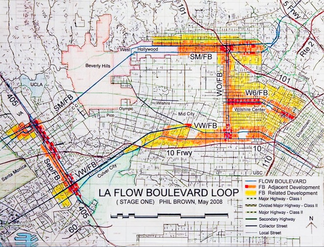
The Loop is comprised of: SM/FB, Santa Monica corridor/ Flow Boulevard; WO/FB, Western-Oxford/ Flow Boulevard; VW/FB, Venice-Washington/ Flow Boulevard; Sep/FB, Sepulveda corridor/ Flow Boulevard
The LA Basin Flow Boulevard Loop as a Serving and Protective Form A loop of Flow Boulevards, seen in the plan above, can be used to protect the existing residential communities from Downtown Los Angeles to the ocean. The protective element is the Flow Boulevard Corridors with their ability to absorb the new land use and traffic growth that threatens to haphazardly disperse throughout the existing residential communities in the LA Basin. Growth without a comprehensive plan will change neighborhood character and make severe traffic congestion on streets that now barely operate with level of service D. Besides absorbing traffic and land use growth in a planned way, a Flow Boulevard (FB) is designed to restrict traffic not destined to an adjacent residential neighborhood from going into and cutting through that neighborhood. No more cut through traffic and no more congested Boulevards!
The serving aspect of Flow Boulevards, which is predominantly a transportation form, is by solving congestion and getting Los Angeles to work! Work in the figurative sense and in the literal sense of getting from home to a place of work or other such activity. Much of this website is based upon the actual transportation benefits the FB concept is built upon; how higher capacity is achieved within existing street right of ways (ROW). To fully appreciate the concept, one should be familiar with those features (see menu, How the FB Works). The present discussion is more about fairly broad planning relationships of transportation to land use in the Basin than it is to transportation operation. Yet, one should be aware of what the Flow Boulevard concept is based upon.
The main objective of this overall study called The LA Basin FB Loop and Corridor Study has been to propose a solution to the problem of congestion and probable land use impacts in the Basin. The “loop form” is a product of recognizing important transportation corridors and that just two FB’s are needed for future east-west growth in travel demand through the Basin. Additionally, it is a geographical fact that there are many fine residential communities centered in the LA Basin; not to be impacted with more congestion and new land use conflicts! Therefore the loop of high capacity FB’s provides the optimal form for transportation service and land use protection within the LA Basin.
A somewhat more detailed explanation of the transportation to land use relationships is presented below in the Transportation Corridor Study section on page three entitled The LA Basin FB Loop with Rail. Also within that study is a discussion about improved access to Downtown entitled Downtown, Loop and “FB Spurs”.
Further consideration of improved access to Downtown by way of Flow Boulevards is given in this plan. Downtown is very much an important element in the LA Basin but may have over shadowed the rest of the Basin in the making of plans to date. That is also an objective of this overall Basin study; to give appropriate balance to each of its parts so the whole will benefit. The missing element that will benefit the whole by tying it all together, by solving the problems of congestion, getting commuters to work centers and directing good land use in the Basin is by developing Flow Boulevard corridors in the right relationships to the transportation network and existing and future land use.
It is within the qualities and capabilities of the FB corridor itself, with its combined increase of vehicular capacity and new higher density land use development, that true “smart growth corridors” can emerge to solve congestion and give needed new land use to the Basin. This is a new transportation corridor structure that can tie all the centers of the Basin together and allow further growth in those centers as well. In the FB corridor you can expect an urbane, dense, diverse, activity with a mix of land uses and yes that density that brings a pedestrian walking environment and open space system to emerge along the corridor. Meanwhile the existing residential areas adjacent to the corridors are protected, would refine their neighborhood improvements and they would benefit from the new land use amenities and services that develop in the adjacent FB corridor. The adjacent FB’s includes as well the free flow of vehicular travel and the fast exclusive lane Bus Rapid Transit (BRT) giving circulation throughout the Basin and would serve commuters to get to work centers.
LA Basin Corridor Growth and Some Parts So the 30 mile Basin FB Loop picks up the pressures of new traffic and land use growth thereby preserving the existing residential communities and gets commuters to work centers quickly. This would primarily be west of Western Avenue and inside and outside the Loop, regarding the preservation of residential areas and they would be left much like they are today. The exception is to the east of Western Avenue where revitalization and higher residential density adjacent to Downtown is desirable. There the Flow Boulevard system can be used to advance new, dense, walkable urban environments separate from transportation and FB’s can connect commuters to Downtown with the extending FB corridors and FB Spurs.
Adjacent and along the FB Loop there is the major center of Downtown LA itself and sub-centers that have varying plans for growth and development. The Loop serves these centers with needed increases in vehicular capacity where growth is planned and it also contains and solves for “through traffic” not destined to the centers so as to avoid congestion. The contribution the Loop makes is the accommodating of an increase in bus riders (BRT), automobiles and service vehicles with the necessary capacity to serve travel demand as well as to support the “smart growth” of development in transit corridors connected to work centers. In the “Loop Plan with Rail” (see below page 3), regional rail transit is incorporated for the long distance commuter by way of the Expo Line and a Red Line extension.
Flow Boulevards are built in essentially commercial corridors and by evolving the corridor with greater density of housing and more commercial land use, that effort will help build an elevated level pedestrian circulation and open space system over time (see menu Elements and Travel Demand). The elevated pedestrian system is integral with the objective of evolving higher capacity boulevards through time in a staged manner and with making the new higher density corridor. The elevated pedestrian circulation is needed when that area of the corridor evolves past the stage one development and where traffic signals will no longer occur and pedestrians will no longer cross FB streets at grade level. Whether it takes a decade or many, development prior to stage two should anticipate where elevated pedestrian crossings are needed so that traffic signals may be removed at grade to produce higher vehicular capacities. This would be a safer and more aesthetic urban pedestrian environment as well, that brings a new “urban fabric” to Los Angeles. The elevated pedestrian circulation is up and out of the grade level of vehicular traffic in its own human-scaled realm, providing a context for a new kind of urban design.
Metro’s plans for the Basin are inadequate Metro virtually has no plans to solve vehicular congestion in the Basin. The Metro plans to date do not solve for the volume of future travel demand in the Basin, vehicular or otherwise, and the placement of a Wilshire subway right in the middle of the residential communities would attract unwanted regional commercial land use and along with it, excessive vehicular traffic. This is all to favor the rail transit rider and to the expense of the Basin resident. Those deficiencies are a prescription for major traffic congestion and community impacts that are not acceptable.
The Expo Light Rail Line does not generally interrelate and improve development in its corridor. Generally medium and long distance trips are served in this corridor. It may serve to increase the modal split percentages of transit with the heavy use of autos on the 10 Freeway, which is good. It would serve the commuter, as planned and generally stays away from major disruption except for not providing enough grade separations at major arterials and important pedestrian crossings.
On the other hand, the proposed Wilshire subway extension west of Western would bring more development and vehicular traffic to that corridor thereby upsetting modal split balance and adding too much commercial land use. To avoid disruption to this community, it should remain primarily as a residential corridor west of Western Avenue. It is strongly recommended to put the subway extension, along with regional commercial land use growth, in the Santa Monica corridor, not the Wilshire corridor. The Wilshire corridor between Western Avenue and the City of Santa Monica will not accept the kind of vehicular growth a subway would generate without a great deal of disruption and change. Alternatively the Santa Monica Boulevard corridor already has a good vehicular segment between Century City and the 405, and is a natural and traditional transportation corridor from east of the 5 freeway along the south side of the mountains and out to the 405. This is essentially State Highway Route 2 and was formerly the proposed Beverly Hills Freeway corridor.
The “preliminary” corridor plan on page two, The Santa Monica Flow Boulevard Corridor, will serve to illustrate the fact that it is desirable to be improved east of Century City and shows that the serving of the centers of Downtown, Hollywood, West Hollywood, Beverly Hills, Century City and the Sepulveda Corridor makes it the better transportation corridor to be improved rather than Wilshire.
The point is, wherever the subway is put on the Westside it is going to attract development and growth, as it should! You do not develop a heavy rail half billion dollar per mile facility not to serve. So wherever the subway goes it will eventually need vehicular backup in the 70,000 vehicle per day range (plus bus). The present Wilshire corridor configuration in no way meets the challenge. See the 1973 Wilshire Flow Boulevard proposal below for an idea of what it would take to accommodate heavy traffic. What it shows is that the land use impacts are too great and a Wilshire subway with FB combined would create an unsolvable bottleneck in Beverly Hills. This can be seen in the “corridor study” segment below (on page 3).
Another major aspect of “growth and parts” to be acknowledged is the development of housing and the elevated pedestrian circulation across the FB corridors. Land use development itself, is an integral part of the FB concept and is illustrated more thoroughly in the “Elements” section on this website as previously mentioned. But it should be said here that there are several uses for housing from a corridor and urban design viewpoint. There is housing for community renewal generally, there is housing that helps bring about new relationships to streets whether it be elevated cross street configurations or “buffer configurations” to existing residential. And there is housing that completes urban mixed use areas, pedestrian circulation and open space systems. In short there would be many new creative forms for housing along with their pedestrian circulation and what is interesting, housing makes the Flow Boulevards pay their own way. Yes, development of the FB corridors pay their own way!
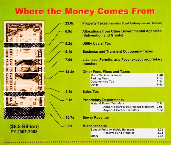
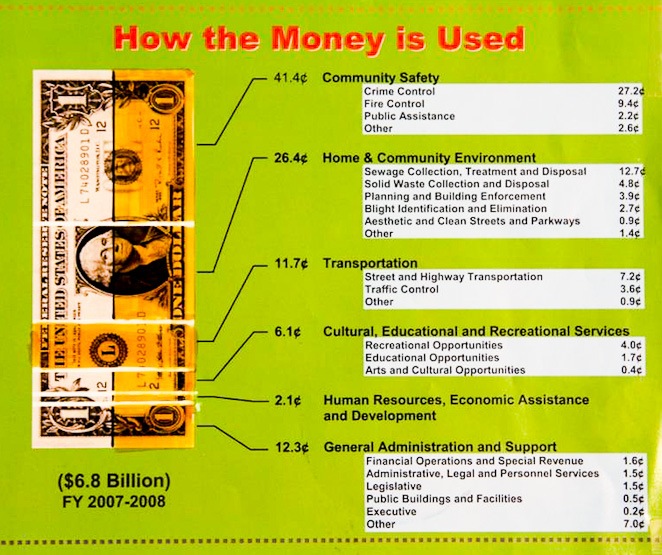
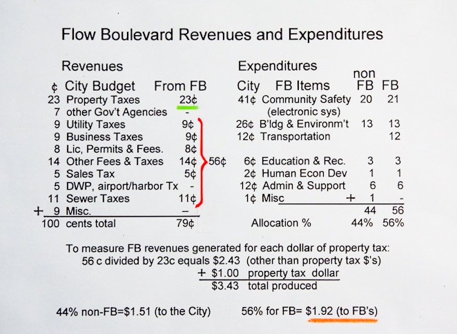
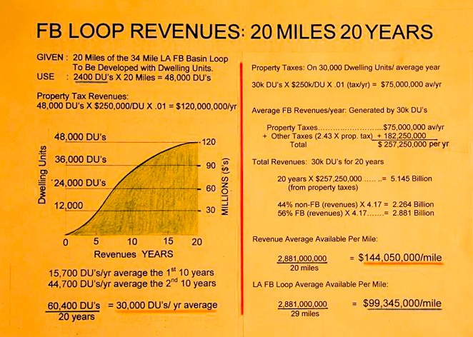
Flow Boulevards Pay Their Own Way The above green background 2008 charts are from the City of LA showing revenues and expenses. The bottom line is that it shows there is approximately another $2.43 for every $1.00 of property tax (a total of $3.43 per annum) that is generated by development. Not being greedy I allocated just $1.92 of that amount from the new housing and development along the FB, or 56% of the revenue to apply to FB roadway and system development. The remaining 44% of revenues can go where it normally goes. But remember that “where ever it normally goes” is not getting short changed because without the FB it would not be getting any of it at all. So Flow Boulevards make money, pay their own way and then some. They are not money pits like rail transportation that cost tax payers every year. It works out that over 20 years with approximately 2400 units (or equivalent) per mile of new construction you can expect $144 million per mile by using the 56% of taxes and fees generated by the land use development that is integral with the Flow Boulevards. Another way of looking at it is, less than the cost of 2 miles of subway can buy 30 miles of Flow Boulevard. Then the City can simply put the revenues from the FB towards paying for police, a River Park, more Flow Boulevard, or maybe paying for a subway at some later date.
For a 30 mile loop times 2400 units/mile (above the number of units displaced) that would be around 60,000 dwelling units along with new commercial and institutional land use (that would likely be in place of some housing). That amount can probably be doubled again for dispersed new development away from the corridor, or a total of about 120,000 dwelling units and that would be maybe 240,000 people now living close to work and urban amenities (let’s not exclude all those retired boomers that would be avoiding the isolation of the suburbs).
This is a plan that could evolve over 25 to 40 years and beyond. The 30 mile loop would be the Basin portion of a 135 mile citywide network (see menu LA Citywide FB Network). The Flow Boulevard corridor urban form is the next step forward that expresses urbanity in the twenty first century in Los Angeles. Freedom of mobility and access to work, education and entertainment are gained for the majority, but also with the conservation of energy and resources brought about by the new urban form called Flow Boulevard allowing shorter trips from home to work as well as greater access to urban amenity. It can also be assumed that vehicles will be transformed over the coming years into various highly fuel conserving vehicles or simply electric (with non-polluting energy sources?).
How Bad Can Congestion Get Without Flow Boulevards? The short answer is congestion in the LA Basin can get on the order of catastrophic. The Travel Demand section on this website is a transportation technical analysis of travel demand and an assignment of that person trip travel demand to all modes of transportation east-west in the LA Basin across a screenline at Fairfax Avenue. The trouble is people do not take the time to read such a thing. But if you do not understand travel demand you can not appreciate what has to be solved for in a plan, what is a good solution and what is no solution at all. The Transportation Corridor Study section below will try to explain and compare various plans for the LA Basin below without too many charts and graphs. Of the three sections of this new addition to this website the Transportation Corridor Study is probably the most important because by comparing the various plans it should become evident that the LA Basin FB Loop will solve the transportation problems in the Basin and begin to set the framework of a new vision for development in Los Angeles.
Some brief comments can be made here to give some measure and overview on the subject of congestion and would be helpful so as to avoid the “catastrophic” congestion due to deficiencies in transportation facilities. To begin with, the projection for the year 2030 that was made in the Travel Demand analysis, when boiled down, resulted in an increase of essentially 27.6% in person trips (pt) from the years between 2005 and 2030. This analysis is represented as the No Rail Plan below. Beginning with an east-west increase of 333,000 person trips (pt) from the year 2005 to the year 2030 and crossing the screenline at Fairfax Avenue, some of it was pared down. There where 40,000 pt “exported” to the Slawson corridor assuming a citywide FB network. And another 26,000 pt in effect were removed with the FB “walking environment” efficiencies, and higher vehicular personage on the 10 freeway and streets generally due to the denser urban form. These volumes refer to the east-west increase in person trips in the LA Basin between the Hollywood and Baldwin Hills along the Fairfax Avenue screenline.
Without the development of Flow Boulevards all freeways, regular boulevards, arterials and the street grid in general, FAIL! In the plans shown in the Corridor Study below with two subways and an Expo Line, they also fail to accommodate expected travel demand without two Flow Boulevards going east-west through the Basin. To help the reader in visualizing the situation of not providing high capacity Flow Boulevards to accommodate new travel demand in the Basin, think about the following. If there were not freeways through the Basin and the surface streets were to take on the task of providing the access to and through the Basin, would there be congestion?
What increase in travel demand should be planned for? It should be noted that SCAG anticipates a 38% population increase across the region generally by 2030, but with a higher percentage inland as opposed to coastal. The coastal percentage being lower assumes continued high levels of sprawl inland. Conversely, one can expect an anti-sprawl urban consolidation trend, and that the LA Basin has regional employment attraction which should make it an area with above average coastal population increase. In addition, there is a “funneling of through traffic” effect due to the geographic placement of the Basin. All considered, the 27.6% increase used in the LA Basin Loop Plan and the No Rail plans seems about right. I think a travel demand increase above 32% would be a little “hot” but an increase of below 20% would be something a NIMBY would come up with.
In regards to population and traffic increases, the Flow Boulevard concept has depth since the Flow Boulevard evolves. The FB plans presented here have less than half of their potential vehicular capacities simply using today’s technology of vehicles on roads. The third stage of a FB has continuous flow of vehicles, no traffic signals and is about three times the capacity found on present day typical boulevards on a lane per lane basis. Those capacities would be around the 2300 vehicles per lane per hour obtainable with continuous flow traffic at the 38 mile per hour speed that is anticipated in stage three with today’s vehicles and technology.
However the third stage roadway, without people going into it to cross streets, is a “guideway” where intelligent transportation or computer controlled higher capacity vehicles could be put in those guideways in some distant future. And they can all be electric vehicles. The future freeway system linked up with a third stage Flow Boulevard system could maybe even have capacities using intelligent transportation of 5,000 vehicles per lane per hour, still giving individual mobility throughout Los Angeles without congestion. If not all the lanes then maybe some lanes like HOV lanes. In that since the FB plans are the first phase of a 75 to 100 year plan for the Los Angeles Basin. This is another reason not to throw too much money at rail by submitting to becoming a “strap hanger” on the nineteenth century technology of the subway. Keep as much freedom of mobility as possible and keep on being creative. Just design it right!
In my inquire of “authoritative” planning (Caltrans, and the City of LA) they do not reflect projections anywhere near those of SCAG. However I think the City of LA is making work easy for itself by ignoring that there will be substantial increased population and traffic growth. My take on the issue is to plan for fairly substantial growth and provide a flexible means to accommodate it, whether it takes a short or long period of time to come about. Once growth appears, plans that did not anticipate substantial growth would be quickly scrapped as insufficient in just a few years. On this last point, there are already substantial traffic pressures due to growth.
Regarding vehicles themselves; the public and government is trying to evolve the entire body of automobiles, trucks and buses to be more fuel (energy) efficient. CAFE standards are in effect, there are hybrids, cars and buses running on compressed natural gas, smart cars of all kinds and plug-in electrics are on their way. These examples are just the beginnings of future innovation. This in combination with shorter trips, less stop and go driving and greater use of transit lead to large reductions in dependence on oil and provide the possible bridge to zero fossil fuel use. It all works together will the objectives of Flow Boulevards and truly “smart growth” corridors. The objective is to gain a 135 mile Citywide Network of Flow Boulevards in Los Angeles so that the reduction in fossil fuel use and transformation of the entire City to a greater efficient use of energy can come about quickly (see menu LA Citywide Network).
The LA Basin is in the middle of the Los Angeles Megalopolis. For the last 40 years LA has been “sprawling” filling up large areas of adjacent counties even. The LA Basin has been in a relatively slow or no growth period. You can expect with a “consolidation” to occur due to resource conservation, including higher densities and legislation to back it up, there can be growth pressures in the LA Basin that have never before been experienced. I think, however, the FB assignment previously made on this website shows that the travel demand increases above 30% can be avoidable for at least 25 to 35 years. And with a “protective transportation plan” the through traffic and the destined traffic to the LA Basin will not disrupt existing communities if FB’s are provided. As for what happens beyond 35 years; those plans would be building on a 30 mile loop able to respond to even further growth, thereby protecting the important central residential feature of Los Angeles while still getting people to work centers.
So whether it takes 25 or 40 years to achieve a 27.6% increase it would not affect the basic transportation plan solution because the numbers are large, the plan should avoid disruption to existing communities and the quality of life should be maintained and raised. Deficiencies and bad placement of transportation facilities can ruin just about everything, so there is good cause to compare different plans and travel demand assignments to avoid short comings in planning.
Corridor Studies and Comparisons
Besides the “No Rail” assignment already made in the before mentioned Travel Demand section (see menu) and reviewed below, there will be descriptions of volumes and particular transportation characteristics of additional plans; the LA Basin FB Loop Plan with Rail, The Metro Plan Deficiencies, a Wilshire Flow Boulevard Plan and last and least the Pico Olympic Plan. This should answer some questions as to what is adequate and what is deficient in transportation planning for the Basin. This kind of discussion will follow the Santa Monica FB Corridor Study below.
Before the Santa Monica Flow Boulevard segment is presented (the northern side of the LA Basin FB Loop), the other three sides of the FB Loop that are already on this website and expressed in detail, should be pointed out.
East Side of Loop (WO/FB) The easterly side is the “Western Ave FB”, and with a click on that name on this website menu the connection will be made.
South Side of Loop (VW/FB) The south side of the FB Loop is the Venice-Washington FB segment. It can be observed with a click on the “Introduction” segment on the menu. Then one must scroll to the plan image named Proposed Flow Boulevards Initial Corridors; charts, perspectives and discussion follows. And more Venice-Washington FB can be viewed by clicking at the menu name of Flow Boulevard 2006. Go to page 2 and scroll to the title The Venice-Washington Corridor appearing next to the plan segment next to Downtown; photos and corridor plans appear in detail.
West Side of Loop (Sep/FB) The west side of the FB Loop is the Sepulveda Corridor FB and is shown in plans and photos in the second half of page 3 in the FB 2006 segment. It is also commented upon at the end of the following Santa Monica Flow Boulevard Corridor presentation just below.