FLOW BOULEVARD
AIA Urban Design Committee Presentation
Applications of Flow Boulevards in Los Angeles
Made by Phil Brown AIA, April 11, 2012
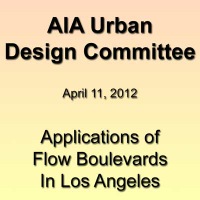
1. Flow Boulevard, a Land use and Transportation Concept 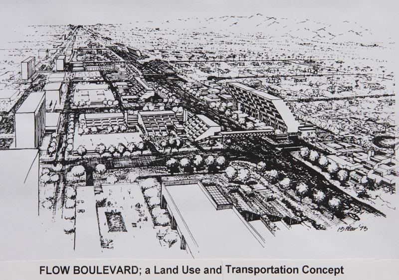
The 1972 basic observation was that there were long corridors in Los Angeles passing through low density residential areas. The basic objective became to use ITS (Intelligent Transportation System) techniques to increase capacity while adding land use density to the corridor. The design choice using these techniques was to stage development over time utilizing architecture in the second and third stages to move pedestrian circulation and open space ”up”, leaving vehicular movement at grade to move freely. It can be said that increased vehicular capacity in the corridor is brought about by the architectural development of aesthetic and safe elevated circulation in a densely developed urban environment. Pedestrian environment makes higher capacity vehicular movement possible, thus unlocking the pent up resources of higher capacity. Existing vehicular volume per lane/per hour about 600 vehicles, stage one 1200, stage two 1800, stage three 2400; for a three hundred percent capacity increase.
2. LA County Travel Movements by Percentage
These are diagrams expressing travel demand by volume (width of line) and direction from place to place in LA County. There are approximately 80 million miles traveled each day with a little over 5 million trips giving about 15 ½ miles in length for the average trip. In this manual assignment technique there are three rings of zones; external, intermediate and internal, connecting 48 zones, which generate and attract trips, that develop the transportation model of County travel demand. The analysis shows that 15% of the “commute trips” by rail to the LA Basin becomes less than 3% of total county trips after $30 billion having been spent on the radial formed rail transit system. This clearly does not adequately serve the county where over 90% of movement is not updated with current objectives and needs for mobility. This can make grave consequences countywide if not balanced by multi-modal transportation development, comprehensive planning and innovative urban design.
3. LA County Potential Multi-Modal Transportation Network
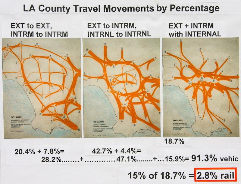
So it is recommended that rail expenditure be restrained so that there is a balanced development of the overall network. This is because Metro as well as people in LA County generally may learn that many of Metro’s premises are incorrect; such as people in the LA Basin do not want a lot of disruptive development and that much has changed with the economic and political picture making it necessary to re-evaluate population and land use growth distribution to better serve its economy. And at this particular juncture it may be correct to say “it’s about the economy stupid”. So much of has changed that there has to be a new emphasis, a reinvention over the next 25 years that includes new jobs, provision for two million more people, more social expenditures on education and healthcare for example, and less on transportation and housing in a generally transforming and consolidation of LA’s urban form. That is also by gaining energy security and economic development accompanied by urban design concepts that unite growth with higher density and increased transportation capacity that reduces vehicular miles traveled. Specifically, exploiting the pent up transportation capacity in the suburban road system to structure the needed growth would be a wise move. Part of this thinking is that the cost of 5 miles of light rail transit would pay for 100 miles of Flow Boulevard or its equal.
4. LA Basin 30 Mile Flow Boulevard Loop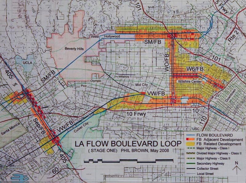
The 30 mile loop becomes essential to provide Basin circulation and the urban design of land use provided by the Flow Boulevard technique allows repair and support of good community function. Consider the following applications and their benefits besides putting lots of architects to work doing good things; A/ provide adequate circulation past communities while mending disparate land uses between the communities, B/ protect existing communities from impacts due to cut through traffic and congestion, C/ provide increased transportation capacity eliminating congestion allowing community amenities and services to develop in other portions of the area, D/ to allow freeways an extended life of function by taking local traffic on to Flow Boulevards, E/ to structure major redevelopment of land use and accessibility, F/ connect and develop disenfranchised communities, G/ to give a major subway transit corridor multi-modal support and balance so it does not disrupt the community, and to become as proposed above as major growth corridors in the consolidating suburbs.
5. An Interchange of Flow Boulevards (Western/Oxford & Venice/Washington)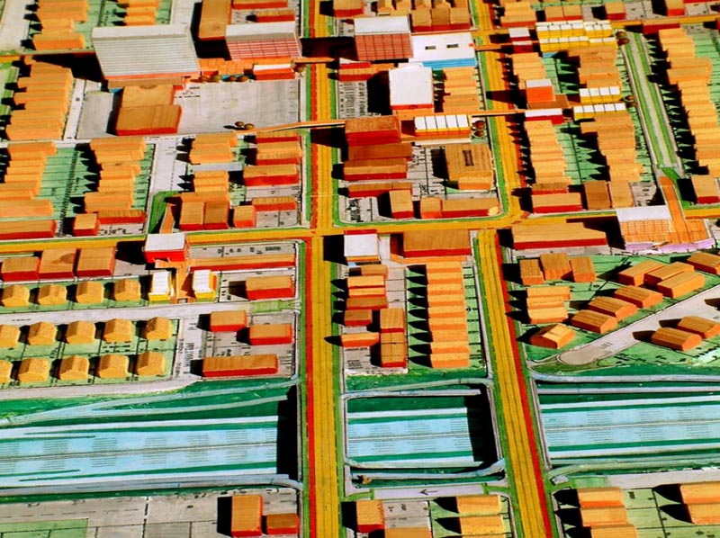
Due to the complexity involved the design was worked out in model form. This model is a Stage 1 depiction of the interchange with pedestrians and vehicular movement all still at grade level. Subsequent Stage 2 relationships of extensive pedestrian elevated circulation and the grade separations of both Venice and Washington over the Western/ Oxford Flow Boulevard were then made to exhibit that condition. A more extensive display can be seen on the website at www.FlowBoulevardPlan.com in the section named Elements and Travel Demand. The major elements of the transportation hierarchy can be seen going from freeway to Flow Boulevard, to arterial to local street and the existing land uses with colored roofs with additional new land use occurring with white roofs showing the community evolving and growing denser.
6. West LA Plan to Eliminate Congestion and Stabilize the Community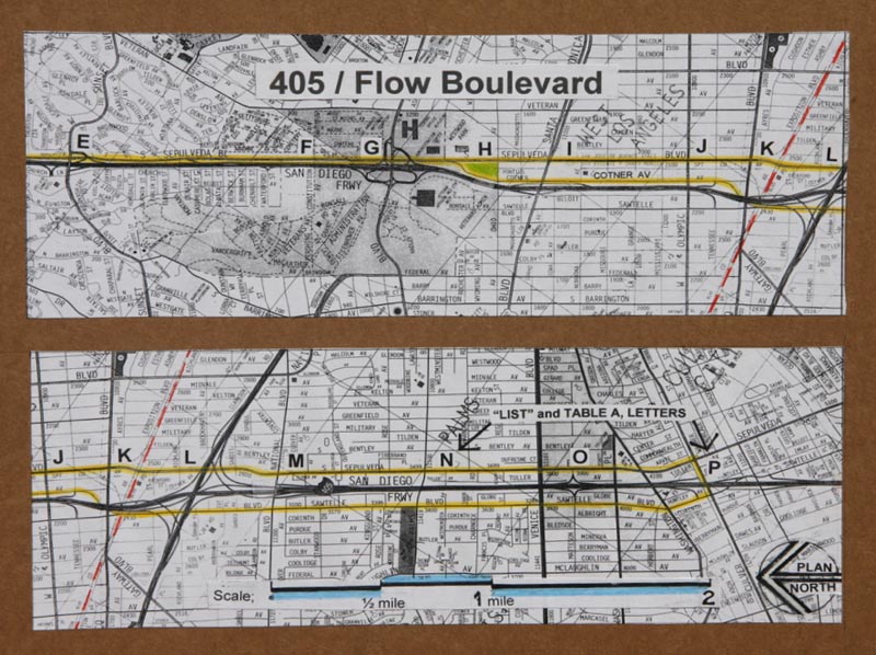
This is a “fix what is broken plan” between Wilshire and Culver Boulevards in the 405 corridor. The objective is to add transportation capacity but not attract more traffic. Essentially what happens is the corridors of the 405 and I-10 are increased in capacity so that the existing traffic cutting through the West LA communities is taken out and put back on the corridors. It is a multi-modal transportation solution utilizing the 405 new additional HOV lane, the Expo light rail line, but most importantly the utilization of a Flow Boulevard as a frontage road to the 405 that adds critical capacity and turning movement opportunity to both the 405 itself and the 405/I-10 interchange. The addition of the Flow Boulevard is the major capacity increasing factor that makes the corridors work and eliminates the congestion on the West LA arterial grid. Approximately 100,000 person trips are removed from the arterial grid north-south and an addition 100,00 person trips are removed from the arterial grid east west thereby eliminating congestion in West LA. With the traffic problem eliminated and the communities stabilized then future planning and improvement to the community can proceed in a balanced manner concerning land use and circulation infrastructure. A more complete description of the plan can be seen at www.flowblvd.com/index3.html and a two page update available by contacting Phil Brown at philbrown44@roadrunner.com .
7, 8 and 9 Manual Assignment Diagrams of West LA Travel Demand 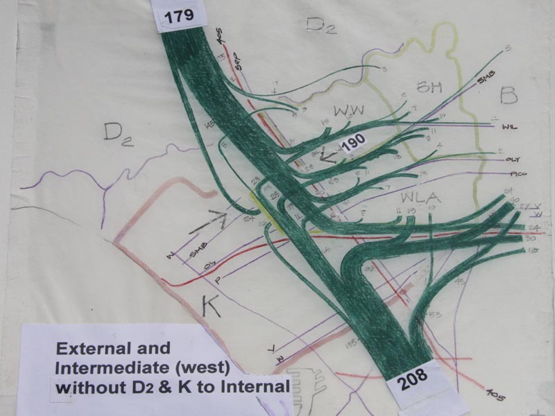
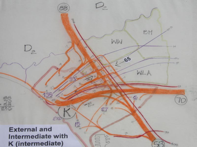
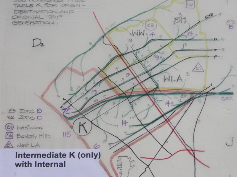
This image and the following two show travel demand to the West LA area. Before this analysis was made the Westside, and I believe Metro as well, did not understand that most of the trips come from the north (valley) and the south (South Bay); only a smaller percentage come from the east. Diagrams; External and Intermediate zones exchanging with Zone A (Westwood, Beverly Hills and West LA/Palms), next External and Intermediate Zones exchanging with Zone K (Santa Monica) and next Intermediate Zone K exchanging with Internal Zones A, B and C (the LA Basin). If the AIA is going to stand for urban design excellence it should make this kind of analytical technique available to its urban designers so that they can really understand the circulation problems to be solved for. The proposed solution to eliminate West LA congestion would cost about $300,000,000 exclusive of the 405 HOV lane and the Expo Line. The City of LA has a planning study that adds a north-south rail transit line to connect the proposed east-west rail lines from LAX to the Expo to the Subway Extension at the VA and a “rail tunnel” from Westwood to the Valley as a potential Measure R project. These rail lines add up to about $15 Billion dollars and would bring new development pressures to the Westside thereby assuring renewed traffic congestion by way of inducing new traffic attracting development.
10. Raised Pedestrian Circulation and Open Space, Vehicles Below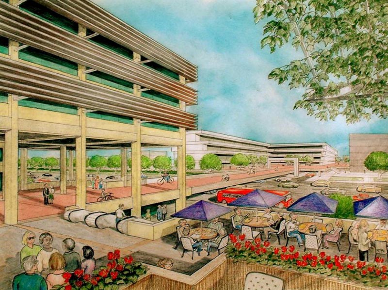
The premise is quality elevated pedestrian environment made architecturally and transportation that is not congested at grade. In the LA Basin and smaller cities it means corridors. In the suburbs it means nodes that introduce walking and small scale vehicle environments beginning to transform the great sprawl of Los Angeles into higher density environments with reduced VMT with a reduction of transportation scale and costs; buses not trains, short trips not long, and support for electric mobility of small cars, electric motor cycles and bikes, walking and biking. So the transformation of LA environment is driven by architecture with three dimensionally organized circulation in mind. Hopefully the AIA can take a leadership role in this transformation influencing politicians, educating the public and initiating the Metro program “Calls for Projects”, prompted by the many jurisdictions of LA County.
Los Angeles City and County need urban design and architects are the appropriate design professionals to carry out the leadership role. Of the many projects associated with 200 miles of Flow Boulevard and related similar facilities in the suburbs I would think these projects could add up to be some 80 square miles of urban design.